IMAGES TAKEN NEAR TO
Barskimming Road, MAUCHLINE, KA5 5HD
Introduction
This page details the photographs taken nearby to Barskimming Road, KA5 5HD by members of the Geograph project.
The Geograph project started in 2005 with the aim of publishing, organising and preserving representative images for every square kilometre of Great Britain, Ireland and the Isle of Man.

There are currently over 7.5m images from over14,400 individuals and you can help contribute to the project by visiting https://www.geograph.org.uk
Image Map
Images are licensed for reuse under creativecommons.org/licenses/by-sa/2.0
Notes
- Clicking on the map will re-center to the selected point.
- The higher the marker number, the further away the image location is from the centre of the postcode.
Image Listing (10 Images Found)
Images are licensed for reuse under creativecommons.org/licenses/by-sa/2.0
Image
Details
Distance
1
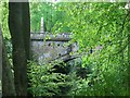
Old Barskimming Bridge.
This ancient bridge dates back to approx. 1770.
It spans the River Ayr some 90 feet (approx.) below. There is no public vehicular access to the bridge.
Image: © Stuart Brabbs
Taken: 12 May 2007
0.05 miles
2
Inside the 'Deer Cave'
The 'Deer Cave' at Barskimming.
Image: © Rab McMurdo
Taken: 10 Feb 2021
0.05 miles
3

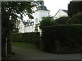
Toll Cottage
The cottage stands where the tolls for crossing Barskimming Bridge used to be collected. It stands at the top of a steep slope leading down to the narrow bridge which is only wide enough for one vehicle to cross at a time. Evidence for this is given by the road sign.
Image: © Bob Forrest
Taken: 23 Dec 2006
0.07 miles
4
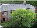
Uninhabited Workers Cottages within Barskimming Estate.
A listed building, this was once Estate workers accommodation. It is perched precariously above the River Ayr some 65 feet (approx) below.
The tree in the foreground is growing out of the top of the cliff. Considerable engineering work was done several years ago to stabilise the building and the cliff as there was a danger of partial collapse.
Image: © Stuart Brabbs
Taken: 12 May 2007
0.07 miles
5
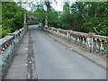
Across the Old Barskimming Bridge.
The view over the bridge. The Courtyard building is out of the picture on the left behind the clipped hedge.
Vehicular access is not permitted.
Image: © Stuart Brabbs
Taken: 12 May 2007
0.08 miles
6
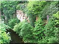
View from the bridge.
Permian sandstone cliffs with the River Ayr below.
Image: © Stuart Brabbs
Taken: 12 May 2007
0.10 miles
7
The Courtyard, Barskimming.
This is a private residence within the Estate.
The weather vane gives the date of completion 1773.
There is an arched passage that leads to the internal courtyard which can be accessed from the other side too.
Image: © Stuart Brabbs
Taken: 12 May 2007
0.14 miles
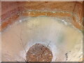
9
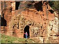
Permian Red Sandstone Cliffs.
The river gorge in Barskimming showing erosion. The River Ayr is below and to the right of the photographer and cliff.
The 2 openings were carved out of the sandstone around the end of the 18th. Century. They now provide shelter for livestock.
The upper chamber is accessed from a point a few metres out of the photograph on the left.
Image: © Stuart Brabbs
Taken: 18 Feb 2007
0.17 miles
10
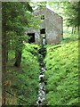
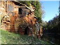
The Mill, Barskimming.
Although there was another much larger Mill not far from here, this is the old Mill building within the estate. The burn that flows below the building towards the camera rises near West Welton Farm to the east of Mauchline and joins the River Ayr close by.
Image: © Stuart Brabbs
Taken: 12 May 2007
0.21 miles