IMAGES TAKEN NEAR TO
Glasgow Road, KILMARNOCK, KA3 6ES
Introduction
This page details the photographs taken nearby to Glasgow Road, KA3 6ES by members of the Geograph project.
The Geograph project started in 2005 with the aim of publishing, organising and preserving representative images for every square kilometre of Great Britain, Ireland and the Isle of Man.

There are currently over 7.5m images from over14,400 individuals and you can help contribute to the project by visiting https://www.geograph.org.uk
Image Map
Images are licensed for reuse under creativecommons.org/licenses/by-sa/2.0
Notes
- Clicking on the map will re-center to the selected point.
- The higher the marker number, the further away the image location is from the centre of the postcode.
Image Listing (9 Images Found)
Images are licensed for reuse under creativecommons.org/licenses/by-sa/2.0
Image
Details
Distance
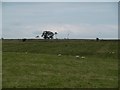
1
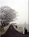
Raithhill farm road end on a frosty morning
Image: © Gordon Brown
Taken: 31 Jan 2006
0.07 miles
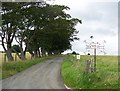
6
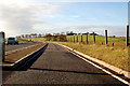
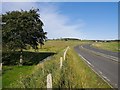
Raithhill Farm and A77
In the foreground, the A77, reduced from a four-lane trunk road, now has a cycle track occupying half its width. Raithhill Farm is on the skyline.
Image: © Mary and Angus Hogg
Taken: 9 Nov 2006
0.17 miles
7
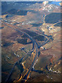
M77 at Tam's Hill from the air
The M77 and the A77 vie for space at Tam's Hill, Junction 6. Viewed from a Glasgow bound flight from Luton.
Image: © Thomas Nugent
Taken: 29 Mar 2013
0.17 miles
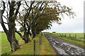
8
Old and new
Taken on the old A77 with the new M77 just visible on the far right horizon.
Image: © Gordon Brown
Taken: 15 Feb 2008
0.23 miles
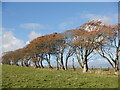
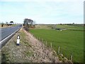
9
Burn passes under the A77
At the right of the picture the main carriageway of the A77 heads north, with the cycle path just to the left. A small burn runs down the hill to the left of the picture, under the trees, and passes under the carriageway of the A77 before merging with the Kingswell Burn.
Image: © Alec MacKinnon
Taken: 20 Sep 2020
0.24 miles