IMAGES TAKEN NEAR TO
Creelshaugh Road, KILMARNOCK, KA3 6DP
Introduction
This page details the photographs taken nearby to Creelshaugh Road, KA3 6DP by members of the Geograph project.
The Geograph project started in 2005 with the aim of publishing, organising and preserving representative images for every square kilometre of Great Britain, Ireland and the Isle of Man.

There are currently over 7.5m images from over14,400 individuals and you can help contribute to the project by visiting https://www.geograph.org.uk
Image Map
Images are licensed for reuse under creativecommons.org/licenses/by-sa/2.0
Notes
- Clicking on the map will re-center to the selected point.
- The higher the marker number, the further away the image location is from the centre of the postcode.
Image Listing (108 Images Found)
Images are licensed for reuse under creativecommons.org/licenses/by-sa/2.0
Image
Details
Distance
1
Glaister Bridge
This small bridge on the Fenwick to Stewarton road crosses the Gardrum Mill Burn.
Image: © Mary and Angus Hogg
Taken: 10 Oct 2006
0.03 miles
2
Old Grave-Slab at Fenwick
The grass has been cleared to reveal this very old grave-slab at Fenwick. It carries only the letters F S 1 WD and the simple carving which might represent a figure.
Image: © Mary and Angus Hogg
Taken: 23 Jun 2015
0.04 miles
3
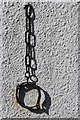
Jougs on wall of Fenwick Parish Church
Iron collar for tethering offenders
Image: © Leslie Barrie
Taken: 23 Mar 2014
0.05 miles
5
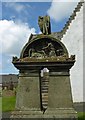
A Double Gravestone at Fenwick
This double stone marks the graves of the Taylor family, with dates ranging from 1840 to 1893. The top panel holds a wonderful portrayal of Christ rising from death assisted by the Angel.
Image: © Mary and Angus Hogg
Taken: 23 Jun 2015
0.05 miles
6
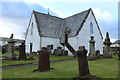
Covenanters in Fenwick Churchyard
Fenwick was a stronghold of the Covenanters who fought in Scotland's religious struggles of the late 17th century. The churchyard contains a number of graves and memorials, all marked with the green plaques shown in this shot. The inscriptions bear witness to the harshness of the treatment meted out by the government forces.
Image: © Mary and Angus Hogg
Taken: 23 Jun 2015
0.05 miles
7
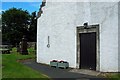
Jougs at Fenwick Church
In the olden days, the kirk was the keeper of public morals and dealt with offences such as sex before marriage. The iron collar and chain hanging on the wall is the original “jougs” into which people were locked to emphasise their punishment. The Fenwick jougs are still in working order - but they're not used nowadays! The church door shows the date of construction, 1643.
Image: © Mary and Angus Hogg
Taken: 23 Jun 2015
0.05 miles
8
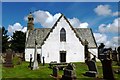
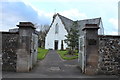
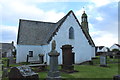
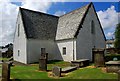
Fenwick Church and Graveyard
Dates on the walls of the church at Fenwick show that it was built in 1643. The belfry was added 23 years later. The building was restored in 1929 to deal with substantial fire damage. The stairs on the right-hand side of this photo lead to the Rowallan Loft, where the local gentry had their seats. The entrance door bears the date 1649.
In the olden days, the kirk was the keeper of public morals and dealt with offences such as sex before marriage. The iron collar and chain hanging on the wall is the original “jougs” into which where people were locked to emphasise their punishment.
The graveyard contains stones and memorials of historical significance, particularly relating to the Covenanting times of the late 17th century. The inscriptions bear witness to the harshness of the treatment meted out by the government forces.
The graveyard has a stone sentry box at both gates, dating back to 1828. They were used to protect recently-buried corpses from body-snatchers who would sell them to doctors and students trying to study anatomy. Ironically, a wall plaque pays tribute to a son of Fenwick who became a respected demonstrator of anatomy in the 1890s.
Image: © Mary and Angus Hogg
Taken: 23 Jun 2015
0.05 miles