Fenwick Church and Graveyard
Introduction
The photograph on this page of Fenwick Church and Graveyard by Mary and Angus Hogg as part of the Geograph project.
The Geograph project started in 2005 with the aim of publishing, organising and preserving representative images for every square kilometre of Great Britain, Ireland and the Isle of Man.

There are currently over 7.5m images from over 14,400 individuals and you can help contribute to the project by visiting https://www.geograph.org.uk
Fenwick Church and Graveyard
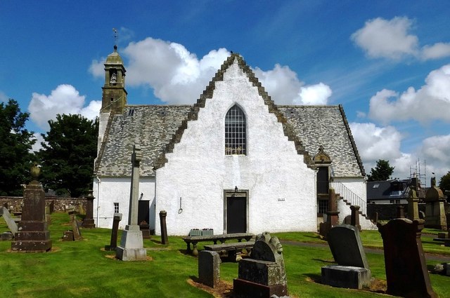
Image: © Mary and Angus Hogg Taken: 23 Jun 2015
Dates on the walls of the church at Fenwick show that it was built in 1643. The belfry was added 23 years later. The building was restored in 1929 to deal with substantial fire damage. The stairs on the right-hand side of this photo lead to the Rowallan Loft, where the local gentry had their seats. The entrance door bears the date 1649. In the olden days, the kirk was the keeper of public morals and dealt with offences such as sex before marriage. The iron collar and chain hanging on the wall is the original “jougs” into which where people were locked to emphasise their punishment. The graveyard contains stones and memorials of historical significance, particularly relating to the Covenanting times of the late 17th century. The inscriptions bear witness to the harshness of the treatment meted out by the government forces. The graveyard has a stone sentry box at both gates, dating back to 1828. They were used to protect recently-buried corpses from body-snatchers who would sell them to doctors and students trying to study anatomy. Ironically, a wall plaque pays tribute to a son of Fenwick who became a respected demonstrator of anatomy in the 1890s.
Images are licensed for reuse under creativecommons.org/licenses/by-sa/2.0
Image Location
Latitude
55.660412
Longitude
-4.441932