IMAGES TAKEN NEAR TO
Cauldhame Rigg, KILMARNOCK, KA3 5QH
Introduction
This page details the photographs taken nearby to Cauldhame Rigg, KA3 5QH by members of the Geograph project.
The Geograph project started in 2005 with the aim of publishing, organising and preserving representative images for every square kilometre of Great Britain, Ireland and the Isle of Man.

There are currently over 7.5m images from over14,400 individuals and you can help contribute to the project by visiting https://www.geograph.org.uk
Image Map
Images are licensed for reuse under creativecommons.org/licenses/by-sa/2.0
Notes
- Clicking on the map will re-center to the selected point.
- The higher the marker number, the further away the image location is from the centre of the postcode.
Image Listing (2 Images Found)
Images are licensed for reuse under creativecommons.org/licenses/by-sa/2.0
Image
Details
Distance
1
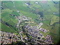
Stewarton and the valley of the Annick Water
Looking northeast over the eastern part of the village. The schools at lower right are Nether Robertland Primary and Stewarton Academy.
Image: © M J Richardson
Taken: 11 May 2016
0.20 miles
2

Stewarton from the southwest
The Annick Water runs through the centre from top to bottom. The two schools at upper right are Nether Robertland Primary and Stewarton Academy.
Image: © M J Richardson
Taken: 11 May 2016
0.23 miles