IMAGES TAKEN NEAR TO
Loudoun Street, KILMARNOCK, KA3 5JB
Introduction
This page details the photographs taken nearby to Loudoun Street, KA3 5JB by members of the Geograph project.
The Geograph project started in 2005 with the aim of publishing, organising and preserving representative images for every square kilometre of Great Britain, Ireland and the Isle of Man.

There are currently over 7.5m images from over14,400 individuals and you can help contribute to the project by visiting https://www.geograph.org.uk
Image Map
Images are licensed for reuse under creativecommons.org/licenses/by-sa/2.0
Notes
- Clicking on the map will re-center to the selected point.
- The higher the marker number, the further away the image location is from the centre of the postcode.
Image Listing (26 Images Found)
Images are licensed for reuse under creativecommons.org/licenses/by-sa/2.0
Image
Details
Distance
1
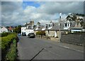
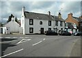
Houses on Loudoun Street
The B778 in Stewarton.
Image: © Richard Sutcliffe
Taken: 5 May 2023
0.01 miles
2
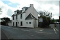
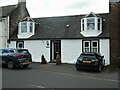
1 Loudoun Street
A prominent early 19th century building at the junction of Loudoun Street and Kirkford. It was probably once a tollhouse and is Category C listed https://portal.historicenvironment.scot/designation/LB51376.
Image: © Richard Sutcliffe
Taken: 5 May 2023
0.03 miles
3
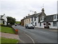
Holm Street, Stewarton
The B778 to Fenwick.
Image: © Richard Webb
Taken: 28 Aug 2016
0.04 miles
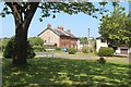
5
Cottages on Kirkford
Category C listed cottages https://portal.historicenvironment.scot/designation/LB41072 dating from 1781.
Image: © Richard Sutcliffe
Taken: 5 May 2023
0.04 miles
6
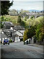
Looking down Loudoun Street
A zoomed view to houses on Loudoun Street and with the Category B listed Annick Water viaduct https://portal.historicenvironment.scot/designation/LB41074 in the distance.
Image: © Richard Sutcliffe
Taken: 5 May 2023
0.05 miles
7
Late 18th century cottage
A Category C listed cottage https://portal.historicenvironment.scot/designation/LB41071 on Kirkford, dating from 1781.
Image: © Richard Sutcliffe
Taken: 5 May 2023
0.05 miles
8
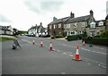
Houses beside the B778
The B778 is called Kirkford here. The white-washed cottages are Category C listed. Cutstraw Road (to the left) is temporarily closed due to roadworks.
Image: © Richard Sutcliffe
Taken: 5 May 2023
0.05 miles
9
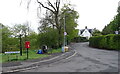
B778, Stewarton
Showing position of Postbox No. KA3 202.
See Image] for postbox.
Image: © JThomas
Taken: 24 May 2021
0.06 miles
10
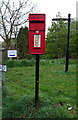
Postbox on Cutstraw Road, Stewarton
Postbox No. KA3 202.
See Image] for context.
Image: © JThomas
Taken: 24 May 2021
0.06 miles