IMAGES TAKEN NEAR TO
Clerkland Road, KILMARNOCK, KA3 5ES
Introduction
This page details the photographs taken nearby to Clerkland Road, KA3 5ES by members of the Geograph project.
The Geograph project started in 2005 with the aim of publishing, organising and preserving representative images for every square kilometre of Great Britain, Ireland and the Isle of Man.

There are currently over 7.5m images from over14,400 individuals and you can help contribute to the project by visiting https://www.geograph.org.uk
Image Map
Images are licensed for reuse under creativecommons.org/licenses/by-sa/2.0
Notes
- Clicking on the map will re-center to the selected point.
- The higher the marker number, the further away the image location is from the centre of the postcode.
Image Listing (25 Images Found)
Images are licensed for reuse under creativecommons.org/licenses/by-sa/2.0
Image
Details
Distance
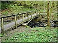
2

Clerkland Burn
Within Cunningham Watt Park.
Image: © Richard Sutcliffe
Taken: 5 May 2023
0.15 miles
3
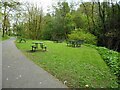
Picnic tables and seats
In Cunningham Watt Park. It is probably best to use the tables on the right, nearest the burn. The ones nearest the path are under tree branches and are covered with bird droppings!
Image: © Richard Sutcliffe
Taken: 5 May 2023
0.15 miles
4
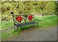
Seat beside the Clerkland Burn
With ladybird-like decoration.
Image: © Richard Sutcliffe
Taken: 5 May 2023
0.15 miles
5

Path beside Cunningham Watt Park
The path runs to the south of the park and high above the bank of the Clerkland Burn.
Image: © Richard Sutcliffe
Taken: 5 May 2023
0.15 miles
6

Stewarton from the air
Looking over the 'Bonnet Toun' from the north from a flight from Glasgow. The railway station and the railway viaduct over Annick Water can be seen. See also Image which was taken at the same time.
Image: © Thomas Nugent
Taken: 6 Mar 2022
0.16 miles
7
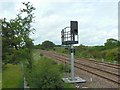
Railway signal
A light signal on the Kilmarnock to Glasgow railway line near Stewarton.
Image: © James Allan
Taken: 24 Jun 2010
0.16 miles
8
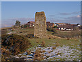
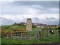
Reuincraig or Corsehill Castle
Showing the only remains left after building of the nearby railway. The ever expanding town of Stewarton behind. http://www.castleuk.net/castle_lists_scotland/64/corsehill.html
Image: © wfmillar
Taken: 17 Feb 2010
0.17 miles
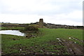
10
Castle
Between the A735 and the railway line, north of Stewarton station.
Image: © Thomas Nugent
Taken: 16 May 2006
0.17 miles