IMAGES TAKEN NEAR TO
Taylor Brown Close, KILMARNOCK, KA3 5DG
Introduction
This page details the photographs taken nearby to Taylor Brown Close, KA3 5DG by members of the Geograph project.
The Geograph project started in 2005 with the aim of publishing, organising and preserving representative images for every square kilometre of Great Britain, Ireland and the Isle of Man.

There are currently over 7.5m images from over14,400 individuals and you can help contribute to the project by visiting https://www.geograph.org.uk
Image Map
Images are licensed for reuse under creativecommons.org/licenses/by-sa/2.0
Notes
- Clicking on the map will re-center to the selected point.
- The higher the marker number, the further away the image location is from the centre of the postcode.
Image Listing (15 Images Found)
Images are licensed for reuse under creativecommons.org/licenses/by-sa/2.0
Image
Details
Distance
1

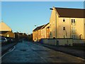
Stewarton from the southwest
The Annick Water runs through the centre from top to bottom. The two schools at upper right are Nether Robertland Primary and Stewarton Academy.
Image: © M J Richardson
Taken: 11 May 2016
0.16 miles
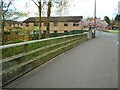
4
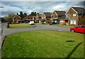
Barbours Park
A cul-de-sac off Holm Street.
Image: © Richard Sutcliffe
Taken: 5 May 2023
0.23 miles
5
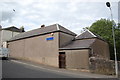
Masonic Lodge, Stewarton, Ayrshire
Lodge Thistle No.127, Stewarton, Ayrshire, Scotland.
Image: © Jim Campbell
Taken: 7 Jun 2009
0.23 miles
6
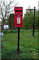
Postbox on Cutstraw Road, Stewarton
Postbox No. KA3 202.
See Image] for context.
Image: © JThomas
Taken: 24 May 2021
0.23 miles
7
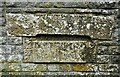
Bridge date stones
Two stones set into the original parapet of Kirkford Bridge Image, giving the building date (1780) and rebuilding date (1979).
ANNO DOMINI
MDCCLXXX
REBUILT
MCMLXXIX
Image: © Richard Sutcliffe
Taken: 5 May 2023
0.24 miles
8
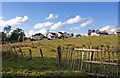
Outskirts of Stewarton
View from the B778 Fenwick Road. The housing is at Draffin Mount.
Image: © wfmillar
Taken: 7 Oct 2010
0.24 miles
9
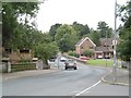
Brides Bridge
The road from Fenwick heading for Stewarton town centre.
Image: © Richard Webb
Taken: 28 Aug 2016
0.24 miles
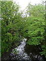
10
Kirkford Bridge
Carrying the B778 over the Annick Water. The original parapet of the bridge (at the far end) contains date stones Image The newer parapet was installed when the bridge was rebuilt in 1979.
Image: © Richard Sutcliffe
Taken: 5 May 2023
0.24 miles