IMAGES TAKEN NEAR TO
Dunlop, KILMARNOCK, KA3 4EN
Introduction
This page details the photographs taken nearby to KA3 4EN by members of the Geograph project.
The Geograph project started in 2005 with the aim of publishing, organising and preserving representative images for every square kilometre of Great Britain, Ireland and the Isle of Man.

There are currently over 7.5m images from over14,400 individuals and you can help contribute to the project by visiting https://www.geograph.org.uk
Image Map
Images are licensed for reuse under creativecommons.org/licenses/by-sa/2.0
Notes
- Clicking on the map will re-center to the selected point.
- The higher the marker number, the further away the image location is from the centre of the postcode.
Image Listing (11 Images Found)
Images are licensed for reuse under creativecommons.org/licenses/by-sa/2.0
Image
Details
Distance
1
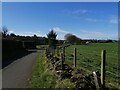
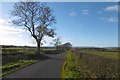
Minor road north of Dunlop
The picture looks south along this minor road as it approaches Dunlop's northern edge.
Image: © Alec MacKinnon
Taken: 8 Apr 2022
0.05 miles
2
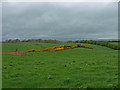
Green Field
Nice splash of Whin (Gorse) gives good colour on a wet Ayrshire day. Looking towards the hills at Muirshiel Regional Park away in the distance.
Image: © wfmillar
Taken: 6 May 2009
0.07 miles
3
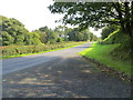
Road at the entrance to Old Mill
Looking north-eastward.
Image: © Peter Wood
Taken: 14 Sep 2016
0.14 miles
4
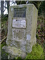
Fundamental Benchmark
This fundamental benchmark sits above a residential driveway off the lane which leaves Dunlop to the east.
Image: © Mark Nightingale
Taken: 23 Mar 2010
0.15 miles
5
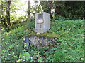
Fundamental Bench Mark - Dunlop
This can be found beside a private driveway near Carlin's Stone at Dunlop.
For more detail see : http://www.bench-marks.org.uk/bm1051
Image: © Peter Wood
Taken: 14 Sep 2016
0.15 miles
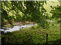
7
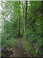
The Wee Glen
A small community woodland beside the Glazart Burn, Dunlop.
Image: © Richard Webb
Taken: 25 Jun 2016
0.18 miles
8
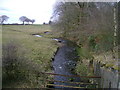
Glazert Burn
Glazert Burn about to pass underneath a lane east of Dunlop.
Image: © Mark Nightingale
Taken: 23 Mar 2010
0.20 miles
10
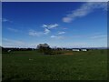
Farmland on Dunlop's north edge
The picture looks west across the fields to the farm at Hapland, from the minor road that arrives at Dunlop from the north.
Image: © Alec MacKinnon
Taken: 8 Apr 2022
0.22 miles