IMAGES TAKEN NEAR TO
Dunlop, KILMARNOCK, KA3 4BY
Introduction
This page details the photographs taken nearby to KA3 4BY by members of the Geograph project.
The Geograph project started in 2005 with the aim of publishing, organising and preserving representative images for every square kilometre of Great Britain, Ireland and the Isle of Man.

There are currently over 7.5m images from over14,400 individuals and you can help contribute to the project by visiting https://www.geograph.org.uk
Image Map
Images are licensed for reuse under creativecommons.org/licenses/by-sa/2.0
Notes
- Clicking on the map will re-center to the selected point.
- The higher the marker number, the further away the image location is from the centre of the postcode.
Image Listing (10 Images Found)
Images are licensed for reuse under creativecommons.org/licenses/by-sa/2.0
Image
Details
Distance
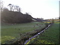
1

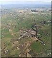
Dunlop Hill from the air
The 138m hill to the west of Dunlop can be seen in the foreground, where the shadow of the peak can be seen on the course of the Glazert Burn, with Black Burn beyond. Dunlop Kirk can be seen on the right.
Image: © Thomas Nugent
Taken: 4 Oct 2019
0.12 miles
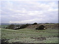
2
Dunlop Hill
Field to the northeast of Dunlop Hill still showing signs of earlier frost.
The north slope of Dunlop Hill is in the centre of the photograph which was taken from Blackburn Bridge.
Image: © Chris Court
Taken: 27 Dec 2005
0.14 miles
3
Dunlop from the air
Looking north east over the village and surrounding farmland.
Image: © Thomas Nugent
Taken: 15 May 2016
0.20 miles
4
Horses
Horses grazing on a pile of old gorse bushes recently cleared from the area of hillside just behind the pile. Over Borland farm in Sq. NS3949 can also be seen in the picture.
Image: © Chris Court
Taken: 27 Dec 2005
0.20 miles
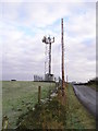
5
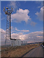
Communications Mast, near Dunlop
Dunlop visible in the distance.
Image: © wfmillar
Taken: 22 Feb 2010
0.20 miles
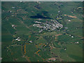
6
Dunlop from the air
The A75 road and the Glasgow to Kilmarnock railway line can be seen running through the village.
Image: © Thomas Nugent
Taken: 7 Apr 2022
0.22 miles
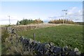
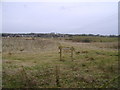
8
Mast
Communications mast in the farm field to the west of the minor road looking north towards Dunlop.
Image: © Chris Court
Taken: 27 Dec 2005
0.23 miles
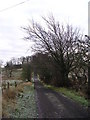
9
Borlandhills
Young trees outside Dunlop.
Image: © Richard Webb
Taken: 6 Nov 2016
0.24 miles
10
Templehouse Woodland
A plantation at the sapling stage of development. The village of Dunlop lies in the background to the left.
Image: © Mark Nightingale
Taken: 23 Mar 2010
0.24 miles