IMAGES TAKEN NEAR TO
Dunlop, KILMARNOCK, KA3 4BL
Introduction
This page details the photographs taken nearby to KA3 4BL by members of the Geograph project.
The Geograph project started in 2005 with the aim of publishing, organising and preserving representative images for every square kilometre of Great Britain, Ireland and the Isle of Man.

There are currently over 7.5m images from over14,400 individuals and you can help contribute to the project by visiting https://www.geograph.org.uk
Image Map
Images are licensed for reuse under creativecommons.org/licenses/by-sa/2.0
Notes
- Clicking on the map will re-center to the selected point.
- The higher the marker number, the further away the image location is from the centre of the postcode.
Image Listing (2 Images Found)
Images are licensed for reuse under creativecommons.org/licenses/by-sa/2.0
Image
Details
Distance
1
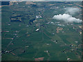
Lugton from the air
Lugton, in the centre of the photo, was once served by two railway stations on different lines. Lugton railway station was on the Glasgow, Barrhead and Kilmarnock Joint Railway line. It opened in 1871 and closed to passengers in 1966. The Lanarkshire and Ayrshire Railway's short lived Lugton station opened in 1903 and closed 4 July 1932. That line ran to Ardrossan from Glasgow.
The present day Glasgow to Kilmarnock line can be seen running from the loch in the distance down to the lower right corner. The disused lines to Beith and Glengarnock can be seen in the lower left corner. The disused line to Neilston can to the left tip of the big cloud.
Image: © Thomas Nugent
Taken: 15 May 2016
0.09 miles
2
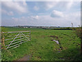
Open gate to farmland
Looking across field to Dunlop.
Image: © wfmillar
Taken: 28 Apr 2009
0.19 miles