IMAGES TAKEN NEAR TO
Stewarton, KILMARNOCK, KA3 3EQ
Introduction
This page details the photographs taken nearby to KA3 3EQ by members of the Geograph project.
The Geograph project started in 2005 with the aim of publishing, organising and preserving representative images for every square kilometre of Great Britain, Ireland and the Isle of Man.

There are currently over 7.5m images from over14,400 individuals and you can help contribute to the project by visiting https://www.geograph.org.uk
Image Map
Images are licensed for reuse under creativecommons.org/licenses/by-sa/2.0
Notes
- Clicking on the map will re-center to the selected point.
- The higher the marker number, the further away the image location is from the centre of the postcode.
Image Listing (3 Images Found)
Images are licensed for reuse under creativecommons.org/licenses/by-sa/2.0
Image
Details
Distance
1
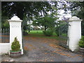
Gates to Kennox
the house can just be seen through the trees.
Image: © wfmillar
Taken: 17 Oct 2006
0.13 miles
2
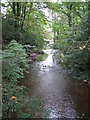
Glazert Burn
Burn running beside Kennox House.
Image: © wfmillar
Taken: 17 Oct 2006
0.13 miles
3
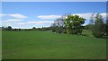
Arable land near Kennox
Beside the Glazert Burn. Most of the ground around here is under pasture.
Image: © Richard Webb
Taken: 21 May 2013
0.16 miles