IMAGES TAKEN NEAR TO
Dunlop Road, KILMARNOCK, KA3 3DX
Introduction
This page details the photographs taken nearby to Dunlop Road, KA3 3DX by members of the Geograph project.
The Geograph project started in 2005 with the aim of publishing, organising and preserving representative images for every square kilometre of Great Britain, Ireland and the Isle of Man.

There are currently over 7.5m images from over14,400 individuals and you can help contribute to the project by visiting https://www.geograph.org.uk
Image Map
Images are licensed for reuse under creativecommons.org/licenses/by-sa/2.0
Notes
- Clicking on the map will re-center to the selected point.
- The higher the marker number, the further away the image location is from the centre of the postcode.
Image Listing (58 Images Found)
Images are licensed for reuse under creativecommons.org/licenses/by-sa/2.0
Image
Details
Distance
1
Castle
Between the A735 and the railway line, north of Stewarton station.
Image: © Thomas Nugent
Taken: 16 May 2006
0.08 miles
3
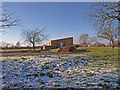
Recreation Ground, Stewarton
The building serving the grounds is heavily covered in graffiti and boarded up.
Image: © wfmillar
Taken: 17 Feb 2010
0.09 miles

5
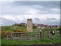
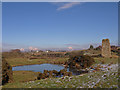
Old Corsehill Castle
This tower is sometimes known locally as Reuincraig Castle, but that name derives from 'Ruin Crag' or 'Ruin Castle' so it can hardly have been the original name of the building. It was most probably Old Corsewall Castle, a medieval stronghold of the Cunningham family which fell into ruins in the 16th century. Most of the surviving stonework of the castle was removed about 1870 for construction of a nearby embankment on the Glasgow, Barrhead and Kilmarnock Railway but the railway company left this corner tower standing, as a historical feature to be seen by passengers in passing trains. Some repair work seems to have been carried out at that time to ensure the tower would continue to stand. This tower is sometimes confused with Corsehill Castle which was built to replace the ruined Old Corsehill at a site on the opposite side of the road. No trace whatsoever of this castle now remains.
Image: © James Allan
Taken: 24 Jun 2010
0.09 miles
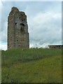
6
Reuincraig or Corsehill Castle
The white buildings in the distance are at Meikle Corsehill. The left one being the Towerhouse.
Image: © wfmillar
Taken: 17 Feb 2010
0.11 miles
7
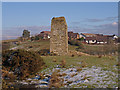
Reuincraig or Corsehill Castle
Showing the only remains left after building of the nearby railway. The ever expanding town of Stewarton behind. http://www.castleuk.net/castle_lists_scotland/64/corsehill.html
Image: © wfmillar
Taken: 17 Feb 2010
0.12 miles
9
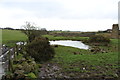
Flooded Field next to Corsehill Castle, Stewarton
Image: © Billy McCrorie
Taken: 18 Mar 2014
0.12 miles
10

Stewarton from the air
Looking over the 'Bonnet Toun' from the north from a flight from Glasgow. The railway station and the railway viaduct over Annick Water can be seen. See also Image which was taken at the same time.
Image: © Thomas Nugent
Taken: 6 Mar 2022
0.12 miles