IMAGES TAKEN NEAR TO
Kilwinning Road, KILMARNOCK, KA3 3DL
Introduction
This page details the photographs taken nearby to Kilwinning Road, KA3 3DL by members of the Geograph project.
The Geograph project started in 2005 with the aim of publishing, organising and preserving representative images for every square kilometre of Great Britain, Ireland and the Isle of Man.

There are currently over 7.5m images from over14,400 individuals and you can help contribute to the project by visiting https://www.geograph.org.uk
Image Map
Images are licensed for reuse under creativecommons.org/licenses/by-sa/2.0
Notes
- Clicking on the map will re-center to the selected point.
- The higher the marker number, the further away the image location is from the centre of the postcode.
Image Listing (63 Images Found)
Images are licensed for reuse under creativecommons.org/licenses/by-sa/2.0
Image
Details
Distance
1
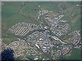
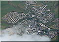
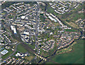
Stewarton from the air
Stewarton dates back to the 12thC https://en.wikipedia.org/wiki/Stewarton and has a population of around 6500. It is served by Stewarton railway station which is to the left of the large buildings in the foreground. Part of the Category B Listed Annick Water railway viaduct http://portal.historicenvironment.scot/designation/LB41074 can be seen in the lower right corner.
Image: © Thomas Nugent
Taken: 17 Apr 2017
0.01 miles
3
Stewarton from the air
Stewarton dates back to the 12thC https://en.wikipedia.org/wiki/Stewarton and has a population of around 6500. It is served by Stewarton railway station which is to the left of the large buildings in the foreground. The Category B Listed Annick Water railway viaduct http://portal.historicenvironment.scot/designation/LB41074 can also be seen in the foreground.
Image: © Thomas Nugent
Taken: 17 Apr 2017
0.07 miles
4
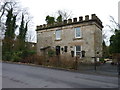
Former gatehouse
This building was once a gatehouse to Lainshaw Estate in Stewarton
Image: © James Allan
Taken: 25 Dec 2015
0.07 miles
5
Stewarton from the air
Stewarton dates back to the 12thC https://en.wikipedia.org/wiki/Stewarton and has a population of around 6500. It is served by Stewarton railway station which is obscured by cloud in this photo.
Image: © Thomas Nugent
Taken: 17 Apr 2017
0.08 miles
6

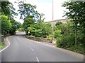
Lainshaw Street
Looking at four arches of the viaduct over the road named Lainshaw Street.
Image: © Malcolm Neal
Taken: 20 Mar 2022
0.09 miles
7
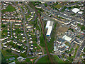
Stewarton from the air
Stewarton railway station and the Hyspec Engineering works https://hyspecengineering.co.uk/ are prominent.
Image: © Thomas Nugent
Taken: 3 May 2019
0.10 miles
8
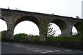
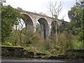
Stewarton Viaduct
Carries the Kilmarnock to Glasgow Railway.
Image: © JThomas
Taken: 23 May 2021
0.10 miles
10
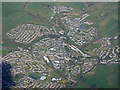
Stewarton from the air
Stewarton dates back to the 12thC https://en.wikipedia.org/wiki/Stewarton and has a population of around 6500. It is served by Stewarton railway station which is to the left of the large buildings in the foreground. The Category B Listed Annick Water railway viaduct http://portal.historicenvironment.scot/designation/LB41074 can be seen in the foreground, with the straight line of High Street beyond.
Image: © Thomas Nugent
Taken: 17 Apr 2017
0.12 miles