IMAGES TAKEN NEAR TO
The Brae, KILMARNOCK, KA3 2TT
Introduction
This page details the photographs taken nearby to The Brae, KA3 2TT by members of the Geograph project.
The Geograph project started in 2005 with the aim of publishing, organising and preserving representative images for every square kilometre of Great Britain, Ireland and the Isle of Man.

There are currently over 7.5m images from over14,400 individuals and you can help contribute to the project by visiting https://www.geograph.org.uk
Image Map
Images are licensed for reuse under creativecommons.org/licenses/by-sa/2.0
Notes
- Clicking on the map will re-center to the selected point.
- The higher the marker number, the further away the image location is from the centre of the postcode.
Image Listing (63 Images Found)
Images are licensed for reuse under creativecommons.org/licenses/by-sa/2.0
Image
Details
Distance
1
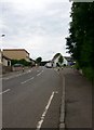
Irvine Road, Kilmaurs
Looking towards the railway bridge carrying the Kilmarnock - Glasgow line over the road.
Image: © Gordon Brown
Taken: 22 May 2017
0.04 miles
4
Bridge underneath Kilmaurs Station
Image: © Bartolo Creations
Taken: 29 Mar 2022
0.10 miles
5

Railway bridge over Crofthead Road, Kilmaurs
Narrow bridge controlled by traffic lights.
Image: © JThomas
Taken: 23 May 2021
0.10 miles
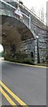
6
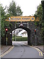
Kilmaurs - an intriguing bridge
The railway bridge on Sunnyside has a number of unusual features. Traffic lights control road traffic under the single-lane bridge, but also act as an elongated pedestrian crossing facility, so narrow is the roadway. The station signage is considerably out of date and obscured by vegetation whose presence is certainly undesirable from a structural viewpoint.
Image: © Peter Whatley
Taken: 15 Sep 2014
0.10 miles
7
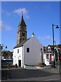
Kilmaurs Tollbooth
The 'Jougs' as it is known locally was the meeting place of the Magistrate and local worthies. It was used as a place of imprisonment and punishment, and the name Jougs comes from the iron neck ring and chain still attached to the external wall near the tower steps. It was also used as a collection point for Custom dues.
Image: © Ian Rainey
Taken: 23 May 2006
0.10 miles
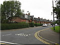
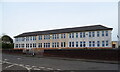
10
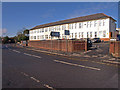
Primary School, Kilmaurs
Sits off Sunnyside across from the junction of the B751
Image: © wfmillar
Taken: 17 Feb 2010
0.12 miles