IMAGES TAKEN NEAR TO
Kilmaurs, KILMARNOCK, KA3 2PQ
Introduction
This page details the photographs taken nearby to KA3 2PQ by members of the Geograph project.
The Geograph project started in 2005 with the aim of publishing, organising and preserving representative images for every square kilometre of Great Britain, Ireland and the Isle of Man.

There are currently over 7.5m images from over14,400 individuals and you can help contribute to the project by visiting https://www.geograph.org.uk
Image Map
Images are licensed for reuse under creativecommons.org/licenses/by-sa/2.0
Notes
- Clicking on the map will re-center to the selected point.
- The higher the marker number, the further away the image location is from the centre of the postcode.
Image Listing (8 Images Found)
Images are licensed for reuse under creativecommons.org/licenses/by-sa/2.0
Image
Details
Distance
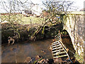
1
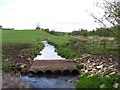
Simple bridge
Appears to be a fairly recent construction.
Image: © Thomas Nugent
Taken: 25 May 2006
0.11 miles
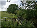
3
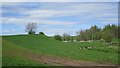
Garrier Burn
Looking upstream with a young wood on the eastern side.
Image: © Richard Webb
Taken: 21 May 2013
0.14 miles
4
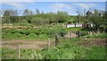
Woodland by the Garrier Burn
Another view of the Irish bridge seen here Image
Image: © Richard Webb
Taken: 21 May 2013
0.15 miles
5
Alton Bridge
Garrier Burn passes under a minor road.
Image: © wfmillar
Taken: 17 Feb 2010
0.15 miles
6
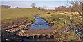
Pipe Bridge, Garrier Burn
Allows cattle to cross the burn.
Image: © wfmillar
Taken: 17 Feb 2010
0.15 miles
7
Garrier Burn south of the road bridge
This is the Garrier Burn, in the countryside west of Kilmaurs, on the other side of the road bridge from the view seen e.g. in Image An improvised footbridge crosses the burn just under the big tree on the skyline.
Image: © Alec MacKinnon
Taken: 12 Aug 2021
0.16 miles
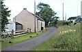
8
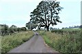
Country road leading to B769 from Kilmaurs
Image: © Alan Reid
Taken: 13 Jul 2021
0.20 miles