IMAGES TAKEN NEAR TO
Crosshouse Road, KILMARNOCK, KA3 2LY
Introduction
This page details the photographs taken nearby to Crosshouse Road, KA3 2LY by members of the Geograph project.
The Geograph project started in 2005 with the aim of publishing, organising and preserving representative images for every square kilometre of Great Britain, Ireland and the Isle of Man.

There are currently over 7.5m images from over14,400 individuals and you can help contribute to the project by visiting https://www.geograph.org.uk
Image Map
Images are licensed for reuse under creativecommons.org/licenses/by-sa/2.0
Notes
- Clicking on the map will re-center to the selected point.
- The higher the marker number, the further away the image location is from the centre of the postcode.
Image Listing (11 Images Found)
Images are licensed for reuse under creativecommons.org/licenses/by-sa/2.0
Image
Details
Distance
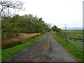
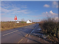
3
Crosshouse Road (B751), Busbiehead
Towards Kilmaurs.
Image: © JThomas
Taken: 23 May 2021
0.05 miles
4
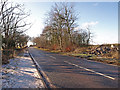
B571 near Kilmaurs
Between Knockentiber and Kilmaurs.
Image: © wfmillar
Taken: 17 Feb 2010
0.15 miles
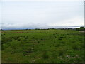
5
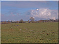
Farmland near Kilmaurs
St. Maurs-Glencairn Parish Church in the distance.
Image: © wfmillar
Taken: 17 Feb 2010
0.16 miles
7
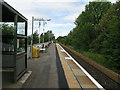
Kilmaurs railway station, looking North
Kilmaurs railway station, looking North towards Glasgow.
Image: © Andrew Reid
Taken: 5 Aug 2011
0.18 miles
8
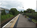
Kilmaurs railway station, looking South
Kilmaurs railway station, looking South towards Kilmarnock.
Image: © Andrew Reid
Taken: 5 Aug 2011
0.18 miles
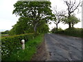
9
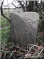
Old Milestone by the B751, Crosshouse Road, Kilmaurs Parish
Ayr granite by the B751, in parish of Kilmaurs (East Ayrshire District), opposite track to farm, at back of verge.
On the 1895 map the mileage to Crosshouse was given as 1¼. The rivet benchmark represents 51.7 m ASL.
The view showing the Crosshouse face is Image
Inscription reads:- Kilmaurs / 1 / Mile // Crosshouse / 1 / Mile
Milestone Society National ID: AYE_CHKU02
Image: © Milestone Society
Taken: Unknown
0.22 miles
10
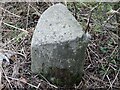
Old Milestone, B751, Crosshouse Road, Knockentiber
Ayr granite by the B751, in parish of Kilmaurs (East Ayrshire District), opposite track to farm, at back of verge.
On the 1895 map the mileage to Crosshouse was given as 1¼. The rivet benchmark represents 51.7 m ASL.
The view showing the Kilmaurs face is Image
Inscription reads:- Kilmaurs / 1 / Mile // Crosshouse / 1 / Mile
Milestone Society National ID: AYE_CHKU02
Image: © Roger Griffith
Taken: 8 Nov 2022
0.22 miles