IMAGES TAKEN NEAR TO
Kilmaurs, KILMARNOCK, KA3 2LU
Introduction
This page details the photographs taken nearby to KA3 2LU by members of the Geograph project.
The Geograph project started in 2005 with the aim of publishing, organising and preserving representative images for every square kilometre of Great Britain, Ireland and the Isle of Man.

There are currently over 7.5m images from over14,400 individuals and you can help contribute to the project by visiting https://www.geograph.org.uk
Image Map
Images are licensed for reuse under creativecommons.org/licenses/by-sa/2.0
Notes
- Clicking on the map will re-center to the selected point.
- The higher the marker number, the further away the image location is from the centre of the postcode.
Image Listing (8 Images Found)
Images are licensed for reuse under creativecommons.org/licenses/by-sa/2.0
Image
Details
Distance
1
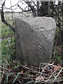
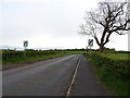
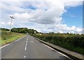
Old Milestone by the B751, Crosshouse Road, Kilmaurs Parish
Ayr granite by the B751, in parish of Kilmaurs (East Ayrshire District), opposite track to farm, at back of verge.
On the 1895 map the mileage to Crosshouse was given as 1¼. The rivet benchmark represents 51.7 m ASL.
The view showing the Crosshouse face is Image
Inscription reads:- Kilmaurs / 1 / Mile // Crosshouse / 1 / Mile
Milestone Society National ID: AYE_CHKU02
Image: © Milestone Society
Taken: Unknown
0.18 miles
2
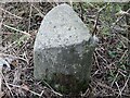
Old Milestone, B751, Crosshouse Road, Knockentiber
Ayr granite by the B751, in parish of Kilmaurs (East Ayrshire District), opposite track to farm, at back of verge.
On the 1895 map the mileage to Crosshouse was given as 1¼. The rivet benchmark represents 51.7 m ASL.
The view showing the Kilmaurs face is Image
Inscription reads:- Kilmaurs / 1 / Mile // Crosshouse / 1 / Mile
Milestone Society National ID: AYE_CHKU02
Image: © Roger Griffith
Taken: 8 Nov 2022
0.18 miles
5
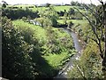
Carmel Water
A small river, a tributary of the Irvine, running through grassland. Seen from the disused Glasgow, Paisley, Kilmarnock and Ayr Railway, now a cycle path.
Image: © Richard Webb
Taken: 9 Sep 2009
0.24 miles
6
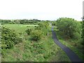
Cycle path
Route 73 of the National Cycle Network.
Image: © Thomas Nugent
Taken: 25 May 2006
0.24 miles
7
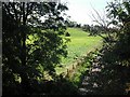
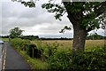
Farmland by Knockentiber
View from bridge carrying the former Glasgow, Paisley, Kilmarnock and Ayr Railway over a lane. The railway trackbed is now a cycle path.
Image: © Richard Webb
Taken: 9 Sep 2009
0.25 miles