IMAGES TAKEN NEAR TO
Bowmore Road, KILMARNOCK, KA3 1TE
Introduction
This page details the photographs taken nearby to Bowmore Road, KA3 1TE by members of the Geograph project.
The Geograph project started in 2005 with the aim of publishing, organising and preserving representative images for every square kilometre of Great Britain, Ireland and the Isle of Man.

There are currently over 7.5m images from over14,400 individuals and you can help contribute to the project by visiting https://www.geograph.org.uk
Image Map
Images are licensed for reuse under creativecommons.org/licenses/by-sa/2.0
Notes
- Clicking on the map will re-center to the selected point.
- The higher the marker number, the further away the image location is from the centre of the postcode.
Image Listing (13 Images Found)
Images are licensed for reuse under creativecommons.org/licenses/by-sa/2.0
Image
Details
Distance
1
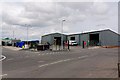
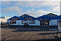
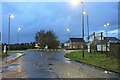
East Ayrshire Council Waste Management - Kilmarnock
Refuse and re-cycling centre
Image: © Ian Rainey
Taken: 9 May 2019
0.17 miles
2
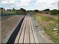
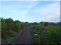
Passing Loop
Loop formed recently to allow engines on goods trains to change ends. This loop has been built on the route of the Kilmarnock to Crosshouse rail line which was closed and has been turned into a cycle route. The path continues in the distance from the access ramp on the left of picture.
Image: © Gordon Dowie
Taken: 12 Jul 2010
0.19 miles
3

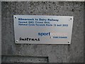
Milepost, National Cycle Network route 73
Situated at the start of a railway conversion: Western Road, Kilmarnock
Image: © Richard Webb
Taken: 9 Sep 2009
0.21 miles
4
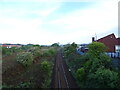
Kilmarnock to Glasgow railway
From the bridge on the B7064.
Image: © JThomas
Taken: 24 May 2021
0.21 miles
5
A roundabout on the B7064 towards West Hillhead
Traffic-free at daybreak on a Sunday.
Image: © Alan Reid
Taken: 6 Nov 2022
0.21 miles
6
Plaque, National Cycle Network, route 73
Celebrating the conversion of a length of the Glasgow, Paisley, Kilmarnock and Ayr Railway into a cycle path. The railway was still shown on maps in 1976, and closed to passenger traffic along with the Kilbarchan Loop in 1966.
Image: © Richard Webb
Taken: 9 Sep 2009
0.22 miles
7
Passing loop on the former Kilmarnock to Crosshouse rail line
From the bridge on the B7064.
Image: © JThomas
Taken: 24 May 2021
0.22 miles
8
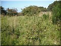
Glasgow, Paisley, Kilmarnock and Ayr Railway
The railway between Kilmarnock and Dalry, closed in 1966. My map, dated 2002 shows that this bit still had rails, but now it is overgrown, save for the cycle path to Irvine.
Image: © Richard Webb
Taken: 9 Sep 2009
0.22 miles
9
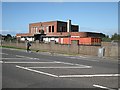
Derelict industrial building
Seen across Western Road, are the abandoned engineering offices for Post Office Telephones (now British Telecom (BT)). These offices were still in use during the late 1980's / early 1990's until centralisation meant they were no longer required.
There was a previous use for the BT building that being of company offices for Southook Potteries. This was part of Shanks (later known as Armitage Shanks). The take over of Shanks resulted in the closure of all premises in Kilmarnock and the building was taken over by Post Office Telephones.
Image: © Richard Webb
Taken: 9 Sep 2009
0.24 miles