IMAGES TAKEN NEAR TO
Irvine Road, LARGS, KA30 8HP
Introduction
This page details the photographs taken nearby to Irvine Road, KA30 8HP by members of the Geograph project.
The Geograph project started in 2005 with the aim of publishing, organising and preserving representative images for every square kilometre of Great Britain, Ireland and the Isle of Man.

There are currently over 7.5m images from over14,400 individuals and you can help contribute to the project by visiting https://www.geograph.org.uk
Image Map
Images are licensed for reuse under creativecommons.org/licenses/by-sa/2.0
Notes
- Clicking on the map will re-center to the selected point.
- The higher the marker number, the further away the image location is from the centre of the postcode.
Image Listing (131 Images Found)
Images are licensed for reuse under creativecommons.org/licenses/by-sa/2.0
Image
Details
Distance
1
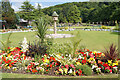
Summer planting in Douglas Park
The small park is immaculately maintained.
Image: © Richard Dorrell
Taken: 10 Aug 2021
0.03 miles
3
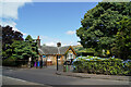
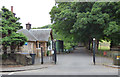
Entrance lodge, Douglas Park
Vehicle entrance from Irvine Road into this very well maintained public park.
Image: © Richard Dorrell
Taken: 10 Aug 2021
0.05 miles
4

Douglas Park, Largs
Created in 1906 when Mr C.J.C. Douglas gifted the land to Largs Town Council for a public park.
Immaculately maintained small public park towards the southern end of the town.
Image: © Richard Dorrell
Taken: 10 Aug 2021
0.05 miles
5
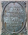
Douglas Park (plaque)
Charles John Cathcart Douglas presented Douglas Park to the town of Largs in 1919
Image: © Raibeart MacAoidh
Taken: 27 Sep 2016
0.05 miles
7
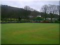
Douglas Park bowling green
Bowling green situated just inside the northwestern entrance of Douglas Park.
Image: © Mark Nightingale
Taken: 21 Jan 2011
0.06 miles
8
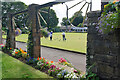
Bowling in Douglas Park
The park is immaculately maintained.
The arches featured here were built in 1947/48, and proved very popular with amateur photographers as ready frames to take snaps of each other.
Image: © Richard Dorrell
Taken: 10 Aug 2021
0.06 miles
9
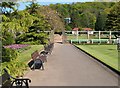
Douglas Park, Largs
This photograph shows the north-western corner of the park. The bowling green, part of which can be seen here, is also shown in Image The park also includes a Victorian Garden (Image) and a Robert Burns Memorial Garden (Image).
The Burns Garden is located just behind the building with the brick-red roof (later demolished — Image), but Douglas Park itself extends considerably further. However, the modern building set on the slope in the background, among the trees, does not lie within the park, but is one of the properties in Bankhouse Grove.
Image: © Lairich Rig
Taken: 13 May 2005
0.07 miles
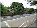
10
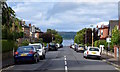
John Street, Largs, North Ayrshire
Looking all the way down John Street towards Broomfield Place.
Image: © Mark S
Taken: 10 Aug 2019
0.07 miles