IMAGES TAKEN NEAR TO
Southannan Estate, LARGS, KA29 0ET
Introduction
This page details the photographs taken nearby to Southannan Estate, KA29 0ET by members of the Geograph project.
The Geograph project started in 2005 with the aim of publishing, organising and preserving representative images for every square kilometre of Great Britain, Ireland and the Isle of Man.

There are currently over 7.5m images from over14,400 individuals and you can help contribute to the project by visiting https://www.geograph.org.uk
Image Map
Images are licensed for reuse under creativecommons.org/licenses/by-sa/2.0
Notes
- Clicking on the map will re-center to the selected point.
- The higher the marker number, the further away the image location is from the centre of the postcode.
Image Listing (36 Images Found)
Images are licensed for reuse under creativecommons.org/licenses/by-sa/2.0
Image
Details
Distance
1

Southanan House - Fairlie, North Ayrshire
Southanan House and the remains of Underbank.
Southanan Canmore ID 41218
https://canmore.org.uk/site/41218/southannan
Image: © Raibeart MacAoidh
Taken: 2 Nov 2020
0.01 miles
2

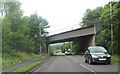
A78 at Hunterston railway bridge
The bridge carries the mineral line over the road from the main line at West Kilbride to the ore terminal at Hunterston.
Image: © Thomas Nugent
Taken: 14 Jul 2018
0.12 miles
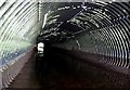
3
Rail bridge over A78
Part of the Hunterston rail network
Image: © John Firth
Taken: 27 Jul 2012
0.12 miles
4

Southannan Lodge
By the A78 Irvine Road at the south end of Fairlie. The Southannan Estate appears to be for sale.
Image: © Thomas Nugent
Taken: 14 Jul 2018
0.14 miles
5

Southannan Lodge
By the A78 Irvine Road at the south end of Fairlie.
Image: © Thomas Nugent
Taken: 14 Jul 2018
0.14 miles
6

Southannan Lodge
An extended traditional lodge cottage, with well maintained gardens - and a gorilla!
Image: © Thomas Nugent
Taken: 14 Jul 2018
0.14 miles
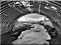
7
Glen Burn - Fairlie
The Glen Burn used to enter the sea at Fence Bay, but it was re-routed when the Hunterston Ore Terminal was being created. From Fencefoot it now flows through culverts under and alongside the A78. It now enters the sea at Southannan Lodge.
Image: © Raibeart MacAoidh
Taken: 6 Mar 2017
0.15 miles
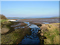
8

Culvert at Southannan Sands
The Glen Burn enters the Clyde at this point.
Image: © Thomas Nugent
Taken: 14 Jul 2018
0.16 miles
10
Glen Burn - Fairlie, North Ayrshire
The Glen Burn used to enter the sea at Fence Bay, but it was re-routed when the Hunterston Ore Terminal was being created. From Fencefoot it now flows through culverts under and alongside the A78. It now enters the sea at Southannan Lodge.
Image: © Raibeart MacAoidh
Taken: 20 Jan 2021
0.17 miles