IMAGES TAKEN NEAR TO
College Street, ISLE OF CUMBRAE, KA28 0HF
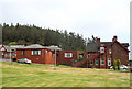
Introduction
This page details the photographs taken nearby to College Street, KA28 0HF by members of the Geograph project.
The Geograph project started in 2005 with the aim of publishing, organising and preserving representative images for every square kilometre of Great Britain, Ireland and the Isle of Man.

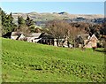
There are currently over 7.5m images from over14,400 individuals and you can help contribute to the project by visiting https://www.geograph.org.uk
Image Map
Images are licensed for reuse under creativecommons.org/licenses/by-sa/2.0
Notes
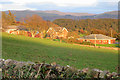
- Clicking on the map will re-center to the selected point.
- The higher the marker number, the further away the image location is from the centre of the postcode.
Image Listing (29 Images Found)
Images are licensed for reuse under creativecommons.org/licenses/by-sa/2.0
Image
Details
Distance
1
The Lady Margaret Hospital - Millport
Looking towards The Lady Margarget Hospital and Irish Law and Knockside Hills on the mainland.
Image: © Raibeart MacAoidh
Taken: 29 Nov 2017
0.00 miles
2
Lady Margaret Hospital
Originally an isolation hospital for patients suffering from infectious diseases, it was named after Lady Margaret Crichton-Stuart, who opened it in 1948.
Image: © Anne Burgess
Taken: 19 Oct 2019
0.02 miles
3
Millport Cottage Hospital
Lady Margaret Hospital, Millport
Image: © John McLeish
Taken: 3 May 2007
0.03 miles
4
The Lady Margaret Hospital
A 10 bed hospital on the outskirts of Millport.
Hospital web site: http://www.nhsaaa.net/hospitals/lady-margaret-hospital/ .
Image: © Thomas Nugent
Taken: 25 Feb 2018
0.04 miles
5
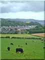
Island cattle
Cattle grazing in fields above Millport. In the distance are houses along the shoreline of Kames Bay.
Image: © Gordon Hatton
Taken: 18 Aug 2013
0.12 miles
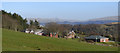
6

A View Over Millport
A view above Breakough Farm (right of shot) en route over the top of Great Cumbrae. The Hunterston Nuclear Power Station complex can be noted on the North Ayrshire mainland coastline. The wind turbine is one of two sited at the former Marine Construction Yard.
Image: © James T M Towill
Taken: 30 May 2015
0.14 miles
7
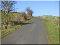
Road to Barbay Hill
Near Breakough Farm.
Image: © Thomas Nugent
Taken: 25 Feb 2018
0.14 miles
8
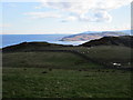
View from Barbay Hill
Looking towards Little Cumbrae (with Arran behind it). The castle there can be made out on its rocky islet as can Ailsa Craig in the far distance.
Image: © Jonathan Thacker
Taken: 31 Mar 2016
0.16 miles
9
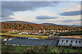
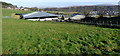
Roofs at Breakough
Beyond the extensive barn roofs at Breakough are some of the houses at the head of Kames Bay. The tree-covered ridge marks the line of the Great Cumbrae Fault.
Image: © Anne Burgess
Taken: 19 Oct 2019
0.17 miles
10
Breakough Farm
On the outskirts of Millport.
Image: © Thomas Nugent
Taken: 25 Feb 2018
0.17 miles