IMAGES TAKEN NEAR TO
Whiting Bay, ISLE OF ARRAN, KA27 8QH
Introduction
This page details the photographs taken nearby to KA27 8QH by members of the Geograph project.
The Geograph project started in 2005 with the aim of publishing, organising and preserving representative images for every square kilometre of Great Britain, Ireland and the Isle of Man.

There are currently over 7.5m images from over14,400 individuals and you can help contribute to the project by visiting https://www.geograph.org.uk
Image Map
Images are licensed for reuse under creativecommons.org/licenses/by-sa/2.0
Notes
- Clicking on the map will re-center to the selected point.
- The higher the marker number, the further away the image location is from the centre of the postcode.
Image Listing (41 Images Found)
Images are licensed for reuse under creativecommons.org/licenses/by-sa/2.0
Image
Details
Distance
1
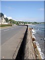
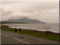
Shore Road and Beach at Whiting Bay
Whiting Bay (Scottish Gaelic: Eadar Dhà Rubha) is the third-largest village on the Isle of Arran. It is approximately 3 miles south of Lamlash. The name Whiting Bay is thought to originate from "Viking" Bay.
Image: © David Dixon
Taken: 23 Sep 2019
0.06 miles
2
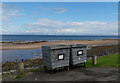
Bins by Shore Road (A841), Whiting Bay, Arran
Image: © habiloid
Taken: 13 Aug 2023
0.06 miles
4
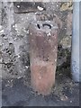
Old Milestone by the A841 in Whiting Bay, Kilbride parish
Arran milestone by the A841, in parish of Kilbride (Arran District), Whiting Bay, on pavement between two drives, adjacent to lamppost, West side of road.
Inscription reads:-
10
(To Brodick Old Quay)
Surveyed
Milestone Society National ID: AYN_ARR10
Image: © Milestone Society
Taken: Unknown
0.08 miles
5
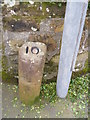
Milestone 10, Arran
Newly painted number
Image: © Brian Robertson
Taken: 13 Mar 2012
0.08 miles
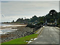
6
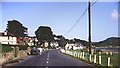
Whiting Bay
This photograph of the A481 through Whiting Bay is facing north along the road to Lamlash and Brodick.
For another photograph (2008) of the A481 about 0.5km south (behind the viewpoint), click here: http://www.geograph.org.uk/photo/1737260 .
The Image is behind the viewpoint.
- - -
The data given for the date taken is the processing date on the slide and therefore could have been taken several weeks earlier.
Image: © Alan Walker
Taken: Unknown
0.09 miles
8
Whiting Bay: benches overlooking the shore
These benches are alongside the main road and provide a good place to enjoy the pleasant view towards Holy Island, whose summit was close to the level of low cloud all day today.
Image: © Chris Downer
Taken: 27 Sep 2010
0.11 miles
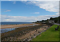
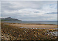
9
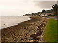
Whiting Bay: shoreline south of village centre
Looking south along the shore, a few minutes' walk from the village centre.
Image: © Chris Downer
Taken: 27 Sep 2010
0.11 miles