IMAGES TAKEN NEAR TO
Newton Road, ISLE OF ARRAN, KA27 8HQ
Introduction
This page details the photographs taken nearby to Newton Road, KA27 8HQ by members of the Geograph project.
The Geograph project started in 2005 with the aim of publishing, organising and preserving representative images for every square kilometre of Great Britain, Ireland and the Isle of Man.

There are currently over 7.5m images from over14,400 individuals and you can help contribute to the project by visiting https://www.geograph.org.uk
Image Map
Images are licensed for reuse under creativecommons.org/licenses/by-sa/2.0
Notes
- Clicking on the map will re-center to the selected point.
- The higher the marker number, the further away the image location is from the centre of the postcode.
Image Listing (75 Images Found)
Images are licensed for reuse under creativecommons.org/licenses/by-sa/2.0
Image
Details
Distance
1
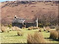
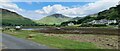
Ruined Cottage
On the opposite side of the road from the church, but further down towards the sea.
Image: © CL Branwhite
Taken: 18 Mar 2008
0.03 miles
3
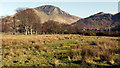
Rough grazing at Lochranza
The rough pasture is at the angle of the A841 and a minor road leaving it to the north. Torr Nead an Eoin is the prominent hill with a craggy upper east face.
Image: © Trevor Littlewood
Taken: 26 Mar 2012
0.04 miles
6
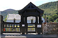
Lychgate, St Bride's Church Lochranza
Image: © Billy McCrorie
Taken: 25 Jun 2018
0.04 miles
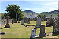
7
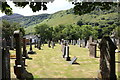
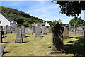
St Bride's Church Graveyard, Lochranza
Image: © Billy McCrorie
Taken: 25 Jun 2018
0.04 miles
8
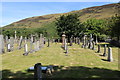
St Bride's Church Graveyard, Lochranza
Image: © Billy McCrorie
Taken: 25 Jun 2018
0.04 miles