IMAGES TAKEN NEAR TO
Brodick, ISLE OF ARRAN, KA27 8FE
Introduction
This page details the photographs taken nearby to KA27 8FE by members of the Geograph project.
The Geograph project started in 2005 with the aim of publishing, organising and preserving representative images for every square kilometre of Great Britain, Ireland and the Isle of Man.

There are currently over 7.5m images from over14,400 individuals and you can help contribute to the project by visiting https://www.geograph.org.uk
Image Map
Images are licensed for reuse under creativecommons.org/licenses/by-sa/2.0
Notes
- Clicking on the map will re-center to the selected point.
- The higher the marker number, the further away the image location is from the centre of the postcode.
Image Listing (16 Images Found)
Images are licensed for reuse under creativecommons.org/licenses/by-sa/2.0
Image
Details
Distance
1
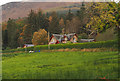
House south-east of Glenshant Hill
Glenshant Hill is part of the southern extent of Goatfell, Arran's highest peak; its slopes rise beyond the building.
Image: © Trevor Littlewood
Taken: 24 Oct 2014
0.02 miles
3
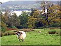
Brodick - sheep above Brodick Bay
Brodick: sheep beside main drive in castle grounds, with view across Brodick Bay towards the ferry terminal.
Image: © Mike Harris
Taken: 11 Oct 2006
0.09 miles
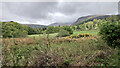
4
Lower part of Cnocan Gorge
This is the Cnocan Burn just above the point where it swings round into fields below the castle.
Image: © David Hawgood
Taken: 14 May 2010
0.09 miles
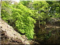
6
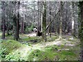
Sun-dappled wood
There's just nothing as peaceful as a mossy sun-dappled wood like this one near Brodick Castle.
Image: © Gordon Brown
Taken: 14 Jun 2008
0.11 miles
7
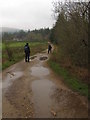
The Track to Goat Fell
Well - not exactly! The road heads towards the woods of Brodick Castle..... the big climb and path up the mountain begin there!
Image: © Andy Beecroft
Taken: 16 Sep 2010
0.12 miles
8
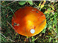
Super Fungus
The fungus was found at the side of the Brodick to Goat Fell footpath. It is rather large isn't it!?.... the silver disk in the bottom right hand corner is a 10p coin! What is this anyway?.... I haven't a clue!
Image: © Andy Beecroft
Taken: 16 Sep 2010
0.13 miles
9
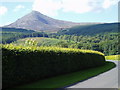
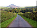
Brodick Castle Drive
The well tended Castle Drive with the peak of Goat Fell dominant on the horizon.
Image: © Bob Peace
Taken: 24 Jul 2007
0.16 miles
10
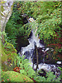
Waterfalls on Cnocan Burn
Brodick: waterfalls on Cnocan Burn from beside a trail in the castle grounds. After heavy rain.
Image: © Mike Harris
Taken: 11 Oct 2006
0.16 miles