IMAGES TAKEN NEAR TO
String Road, ISLE OF ARRAN, KA27 8DR
Introduction
This page details the photographs taken nearby to String Road, KA27 8DR by members of the Geograph project.
The Geograph project started in 2005 with the aim of publishing, organising and preserving representative images for every square kilometre of Great Britain, Ireland and the Isle of Man.

There are currently over 7.5m images from over14,400 individuals and you can help contribute to the project by visiting https://www.geograph.org.uk
Image Map
Images are licensed for reuse under creativecommons.org/licenses/by-sa/2.0
Notes
- Clicking on the map will re-center to the selected point.
- The higher the marker number, the further away the image location is from the centre of the postcode.
Image Listing (7 Images Found)
Images are licensed for reuse under creativecommons.org/licenses/by-sa/2.0
Image
Details
Distance
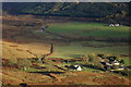
2
Monyquil
Viewed from NR943334 on Binnein na h-Uaimh
Image: © Leslie Barrie
Taken: 5 Dec 2010
0.03 miles

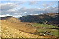
4
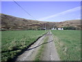
Monyquil Farm
The farm track up to Monyquil, which comes off the B880 String Road. Taken on a warm autumn afternoon. The bit of the square between the farm and the Machrie Water is quite good grassland, but behind the farm the land rises very steeply to Garbh Thorr.
Image: © Kevin Philpott
Taken: 19 Oct 2007
0.08 miles
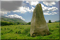
6
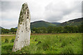
Stone Near Glenloig
Looking towards Glenloig and The String behind
Image: © Hamish Kirkpatrick
Taken: 2 Jun 2008
0.13 miles
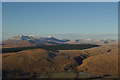
7
Monyquil & Gleann an t-Suidhe
Viewed from the southern slopes of Garbh Thorr
Image: © Leslie Barrie
Taken: 30 Oct 2008
0.15 miles