IMAGES TAKEN NEAR TO
Brodick, ISLE OF ARRAN, KA27 8DA
Introduction
This page details the photographs taken nearby to KA27 8DA by members of the Geograph project.
The Geograph project started in 2005 with the aim of publishing, organising and preserving representative images for every square kilometre of Great Britain, Ireland and the Isle of Man.

There are currently over 7.5m images from over14,400 individuals and you can help contribute to the project by visiting https://www.geograph.org.uk
Image Map
Images are licensed for reuse under creativecommons.org/licenses/by-sa/2.0
Notes
- Clicking on the map will re-center to the selected point.
- The higher the marker number, the further away the image location is from the centre of the postcode.
Image Listing (6 Images Found)
Images are licensed for reuse under creativecommons.org/licenses/by-sa/2.0
Image
Details
Distance
1
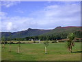
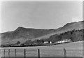
Glen Cloy from Auchrannie Hotel
View west into Glen Cloy from Auchrannie hotel car park.
Image: © Tony Page
Taken: 1 Sep 2005
0.18 miles
4
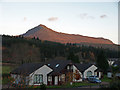
Morning sun on Goatfell
Viewed from Auchrannie Holiday Homes.
Image: © wfmillar
Taken: 12 Nov 2008
0.23 miles
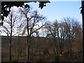
5
Fields in Glen Cloy
Looking towards the houses of High Glencloy. At the time this picture was taken, the nearest house was a hostel run by the Scottish Youth Hostel Association.
Image: © Nigel Brown
Taken: Unknown
0.25 miles
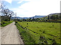
6
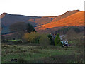
Morning sun Glen Cloy, Arran
The hills at the end of the glen are Sgaith Bhan (left) and Cnoc Dubh of Muileann Gaoithe (right).
Image: © wfmillar
Taken: 12 Nov 2008
0.25 miles