IMAGES TAKEN NEAR TO
Drumbeg Road, GIRVAN, KA26 9LW
Introduction
This page details the photographs taken nearby to Drumbeg Road, KA26 9LW by members of the Geograph project.
The Geograph project started in 2005 with the aim of publishing, organising and preserving representative images for every square kilometre of Great Britain, Ireland and the Isle of Man.

There are currently over 7.5m images from over14,400 individuals and you can help contribute to the project by visiting https://www.geograph.org.uk
Image Map
Images are licensed for reuse under creativecommons.org/licenses/by-sa/2.0
Notes
- Clicking on the map will re-center to the selected point.
- The higher the marker number, the further away the image location is from the centre of the postcode.
Image Listing (76 Images Found)
Images are licensed for reuse under creativecommons.org/licenses/by-sa/2.0
Image
Details
Distance
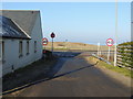
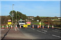
2
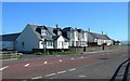
Houses At Turnberry
These houses on the A77 at the southern end of Turnberry village enjoy spectacular views across the Firth of Clyde. The road on the left is the unclassified minor road leading into the southern end of the Carrick Hills.
Image: © Mary and Angus Hogg
Taken: 4 Aug 2008
0.09 miles
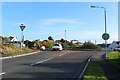
10
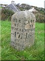
Old Milestone by the A77, Kirkoswald Road, Turnberry
By the A77, in parish of Kirkoswald (Carrick District), junction with the A719, Turnberry, NE corner.
Inscription reads:- : AYR / BY / DUNURE / {arrow to left} 17¼ / BY ST MURRAY / 16 ¼ : : AYR / BY / MAYBOLE / 16 {arrow to right} :
Surveyed
Milestone Society National ID: AYS_AYGV17
Image: © Milestone Society
Taken: Unknown
0.16 miles