IMAGES TAKEN NEAR TO
Dailly, GIRVAN, KA26 9LE
Introduction
This page details the photographs taken nearby to KA26 9LE by members of the Geograph project.
The Geograph project started in 2005 with the aim of publishing, organising and preserving representative images for every square kilometre of Great Britain, Ireland and the Isle of Man.

There are currently over 7.5m images from over14,400 individuals and you can help contribute to the project by visiting https://www.geograph.org.uk
Image Map
Images are licensed for reuse under creativecommons.org/licenses/by-sa/2.0
Notes
- Clicking on the map will re-center to the selected point.
- The higher the marker number, the further away the image location is from the centre of the postcode.
Image Listing (9 Images Found)
Images are licensed for reuse under creativecommons.org/licenses/by-sa/2.0
Image
Details
Distance
1
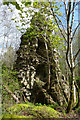
Lochmodie Castle
Lochmodie Castle was built in the 15th century on a well-defended site high above Quarrelhill Burn. All that's left is this overgrown three-storey fragment.
Image: © Mary and Angus Hogg
Taken: 5 May 2016
0.06 miles
2
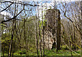
Lochmodie Castle Ruin
Lochmodie Castle was built in the 15th century on a well-defended site high above Quarrelhill Burn. All that's left is this three-storey fragment which really does lean to one side.
Image: © Mary and Angus Hogg
Taken: 5 May 2016
0.06 miles
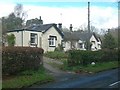
3
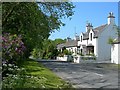
Roadside Cottages
Attractive traditional cottages by the road near Dailly.
Image: © Mary and Angus Hogg
Taken: 9 Jun 2007
0.15 miles
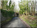
4
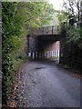
Railway bridge near Dailly
The Ayr to Girvan line passes over a minor road just north of Dailly.
Image: © Oliver Dixon
Taken: 17 Oct 2006
0.15 miles
6
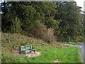
Wayside seat
On the B741, Girvan to Dailly road.
Image: © Oliver Dixon
Taken: 17 Oct 2006
0.19 miles
7
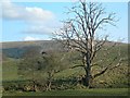
Tree By The Burn
A dead tree beside Quarrelhill Burn, near Dailly.
Image: © Mary and Angus Hogg
Taken: 23 Apr 2008
0.22 miles
8
Cottages On The B741
Brunston Cottages, located on the B741 near Dailly.
Image: © Mary and Angus Hogg
Taken: 24 Apr 2008
0.24 miles
9
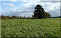
Site of a Prehistoric Cairn
There's nothing visible on the ground now. Centuries of cultivation have improved the land by removing the stones. The 1856 edition of the OS Six-Inch map shows that 4 stone coffins were found here in 1820.
Image: © Mary and Angus Hogg
Taken: 5 May 2016
0.24 miles