IMAGES TAKEN NEAR TO
Pinmore, GIRVAN, KA26 0TJ
Introduction
This page details the photographs taken nearby to KA26 0TJ by members of the Geograph project.
The Geograph project started in 2005 with the aim of publishing, organising and preserving representative images for every square kilometre of Great Britain, Ireland and the Isle of Man.

There are currently over 7.5m images from over14,400 individuals and you can help contribute to the project by visiting https://www.geograph.org.uk
Image Map
Images are licensed for reuse under creativecommons.org/licenses/by-sa/2.0
Notes
- Clicking on the map will re-center to the selected point.
- The higher the marker number, the further away the image location is from the centre of the postcode.
Image Listing (6 Images Found)
Images are licensed for reuse under creativecommons.org/licenses/by-sa/2.0
Image
Details
Distance
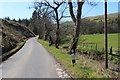
1
B734 near Doularg
On the very minor B road along the Stinchar valley between Barr and Pinmore.
Image: © Oliver Dixon
Taken: 14 Oct 2006
0.02 miles
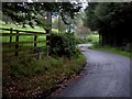
2
Driveway to Doularg in the Stinchar valley
Image: © Oliver Dixon
Taken: 14 Oct 2006
0.03 miles
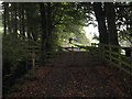
3
Bridge to Auchensoul
Across the River Stinchar.
Image: © Oliver Dixon
Taken: 14 Oct 2006
0.07 miles
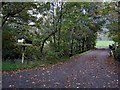
4
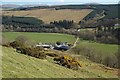
Above Auchensoul
Looking down to the farm from the lower slopes of Kirkdominae Hill. The floodplain of the River Stinchar, in the next square, is shown well in this shot.
Image: © Mary and Angus Hogg
Taken: 2 Apr 2009
0.17 miles
5
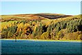
Autumn Colours in the Stinchar Valley
A mid-November view of the Stinchar Valley, near Auchensoul Farm, with frost still showing on the shaded part of the valley floor. Bracken on the hill and larches in the woodland contribute to the autumn colours.
Image: © Mary and Angus Hogg
Taken: 10 Nov 2013
0.21 miles