IMAGES TAKEN NEAR TO
Ballantrae, GIRVAN, KA26 0LD
Introduction
This page details the photographs taken nearby to KA26 0LD by members of the Geograph project.
The Geograph project started in 2005 with the aim of publishing, organising and preserving representative images for every square kilometre of Great Britain, Ireland and the Isle of Man.

There are currently over 7.5m images from over14,400 individuals and you can help contribute to the project by visiting https://www.geograph.org.uk
Image Map
Images are licensed for reuse under creativecommons.org/licenses/by-sa/2.0
Notes
- Clicking on the map will re-center to the selected point.
- The higher the marker number, the further away the image location is from the centre of the postcode.
Image Listing (32 Images Found)
Images are licensed for reuse under creativecommons.org/licenses/by-sa/2.0
Image
Details
Distance
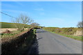
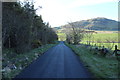
1
Approaching the B734 at Liggetcheek
With view of Knockdolian.
Image: © Billy McCrorie
Taken: 27 Apr 2015
0.01 miles
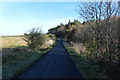
2
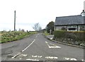
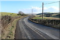
A minor road at Liggetcheek
This minor road links the B734 with the A77.
Image: © Ann Cook
Taken: 28 Apr 2013
0.03 miles
4
Road to Liggetcheek
The hill is Knockdolian.
Image: © Billy McCrorie
Taken: 27 Apr 2015
0.06 miles
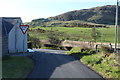
6
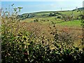
Hillside at Liggetcheek
Not sure what the structure to the left in the middle distance is - possibly a limekiln. Knockdollan Hill on the skyline at the extreme right.
Image: © Oliver Dixon
Taken: 15 Oct 2006
0.11 miles
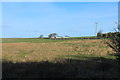
8
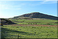
Farmland at Liggetcheek
With view of Knockdolian.
Image: © Billy McCrorie
Taken: 27 Apr 2015
0.14 miles
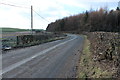
9
The B734 approaching Bougang Farm
On the way to Colmonell.
Image: © Billy McCrorie
Taken: 14 Feb 2015
0.14 miles