IMAGES TAKEN NEAR TO
Brockly View, KILBIRNIE, KA25 7HQ
Introduction
This page details the photographs taken nearby to Brockly View, KA25 7HQ by members of the Geograph project.
The Geograph project started in 2005 with the aim of publishing, organising and preserving representative images for every square kilometre of Great Britain, Ireland and the Isle of Man.

There are currently over 7.5m images from over14,400 individuals and you can help contribute to the project by visiting https://www.geograph.org.uk
Image Map (Loading...)


Getting Data...Please wait
Leaflet Map data © OpenStreetMap
Images are licensed for reuse under creativecommons.org/licenses/by-sa/2.0
Notes
- Clicking on the map will re-center to the selected point.
- The higher the marker number, the further away the image location is from the centre of the postcode.
Image Listing (25 Images Found)
Images are licensed for reuse under creativecommons.org/licenses/by-sa/2.0
Image
Details
Distance
1
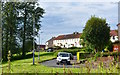
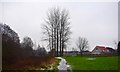
Brockly View, Kilbirnie, North Ayrshire
Brockly View is part of the Milton scheme in Kilbirnie. Construction began in 1949 and took several years to complete.
Stockbridge Crescent is in the background.
Image: © Mark S
Taken: 25 Jul 2019
0.04 miles
2
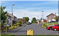
Herriot Avenue, Kilbirnie, North Ayrshire
Herriot Avenue was built in the early 1970s, originally by K C Construction who built the bungalows and two semi-detached houses, then Wimpey who took over a short time later, constructing a further 106 detached and semi-detached houses. The development was completed in June 1976.
Image: © Mark S
Taken: 25 Jul 2019
0.05 miles
3
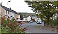
Stockbridge Crescent, Kilbirnie, North Ayrshire
Stockbridge Crescent is part of the Milton scheme in Kilbirnie. Construction began in 1949 and took several years to complete.
Image: © Mark S
Taken: 17 Oct 2020
0.05 miles
4
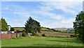
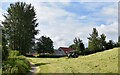
Recreation Ground near Herriot Avenue, Kilbirnie, North Ayrshire
Recreation area at the bottom of Herriot Avenue.
Image: © Mark S
Taken: 25 Jul 2019
0.10 miles
5
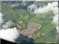
Kilbirnie from the air
A view looking northwest four minutes after leaving Glasgow for France.
Image: © M J Richardson
Taken: 3 Jun 2015
0.11 miles
6
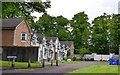
Redheugh Avenue, Kilbirnie, North Ayrshire
Housing development built around 2003 in the grounds of the Redheugh Estate.
These townhouses are situated near the site of the old walled garden.
Image: © Mark S
Taken: 10 Jun 2020
0.12 miles
7
Near Stockbridge Crescent, Kilbirnie, North Ayrshire
The first cut of grass since the start of lockdown.
Image: © Mark S
Taken: 20 Jun 2020
0.13 miles
8
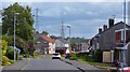
Herriot Avenue, Kilbirnie, North Ayrshire
Herriot Avenue was built in the early 1970s, originally by K C Construction who built the bungalows and two semi-detached houses, then Wimpey who took over a short time later, constructing a further 106 detached and semi-detached houses. The development was completed in June 1976.
Image: © Mark S
Taken: 26 Jul 2019
0.14 miles
9
Towards Lynn Drive, Kilbirnie, North Ayrshire
Looking towards Lynn Drive from the path that winds alongside the River Garnock.
Image: © Mark S
Taken: 19 Jan 2019
0.15 miles
10
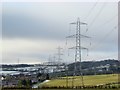
Lining Up
From Dipple Road on a cold February morning in 2015, a row of pylons extends into the distance.
On the left is Herriot Avenue, a Wimpey housing development built in the 1970s.
Image: © Mark S
Taken: 5 Feb 2015
0.18 miles