IMAGES TAKEN NEAR TO
School Road, KILBIRNIE, KA25 7AU
Introduction
This page details the photographs taken nearby to School Road, KA25 7AU by members of the Geograph project.
The Geograph project started in 2005 with the aim of publishing, organising and preserving representative images for every square kilometre of Great Britain, Ireland and the Isle of Man.

There are currently over 7.5m images from over14,400 individuals and you can help contribute to the project by visiting https://www.geograph.org.uk
Image Map
Images are licensed for reuse under creativecommons.org/licenses/by-sa/2.0
Notes
- Clicking on the map will re-center to the selected point.
- The higher the marker number, the further away the image location is from the centre of the postcode.
Image Listing (124 Images Found)
Images are licensed for reuse under creativecommons.org/licenses/by-sa/2.0
Image
Details
Distance
1
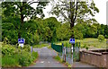
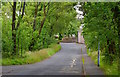
Former Garnock Academy Site, Kilbirnie, North Ayrshire
Exit of the former Garnock Academy site.
The road is still in use serving Moorpark Primary School.
Image: © Mark S
Taken: 9 Jun 2020
0.03 miles
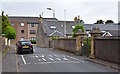
2
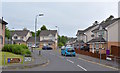
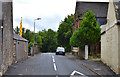
School Road/Ladyland Place, Kilbirnie, North Ayrshire
Just off School Road lies Ladyland Place, built around 2007 on the site of the former Ladyland School which closed in 1978.
Notice the brown tourist information sign for Moorpark House is still in situ on the railing on the left even though it closed as a hotel nearly four years previously.
Image: © Mark S
Taken: 9 Jun 2020
0.03 miles
3
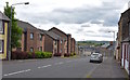
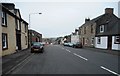
Cochrane Street, Kilbirnie, North Ayrshire
The view down Cochrane Street towards School Wynd.
Image: © Mark S
Taken: 9 Jun 2020
0.04 miles
5
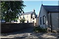
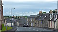
School Road, Kilbirnie, North Ayrshire
The site of the former Garnock Academy secondary school is on the left.
Image: © Mark S
Taken: 23 Jul 2019
0.04 miles
7
Glasgow Street, Kilbirnie, North Ayrshire
Looking along Glasgow Street from Cochrane Street.
Image: © Mark S
Taken: 4 Jul 2020
0.05 miles
8
Cochrane Street/School Wynd, Kilbirnie, North Ayrshire
Looking down Cochrane Street with Glasgow Street to the right and School Wynd beyond.
The A760 is still visible at the top of the picture, continuing on out of the town.
Image: © Mark S
Taken: 27 Jul 2019
0.06 miles
9
Glasgow Street, Kilbirnie, North Ayrshire
St. Columba’s Church is out of sight on the right.
Image: © Mark S
Taken: 9 Jun 2020
0.06 miles
10
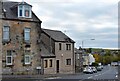
School Wynd, Kilbirnie, North Ayrshire
The tenement on the left appears on an 1856 map of the town.
Image: © Mark S
Taken: 17 Oct 2020
0.06 miles