IMAGES TAKEN NEAR TO
Balgray Avenue, KILBIRNIE, KA25 6DP
Introduction
This page details the photographs taken nearby to Balgray Avenue, KA25 6DP by members of the Geograph project.
The Geograph project started in 2005 with the aim of publishing, organising and preserving representative images for every square kilometre of Great Britain, Ireland and the Isle of Man.

There are currently over 7.5m images from over14,400 individuals and you can help contribute to the project by visiting https://www.geograph.org.uk
Image Map
Images are licensed for reuse under creativecommons.org/licenses/by-sa/2.0
Notes
- Clicking on the map will re-center to the selected point.
- The higher the marker number, the further away the image location is from the centre of the postcode.
Image Listing (12 Images Found)
Images are licensed for reuse under creativecommons.org/licenses/by-sa/2.0
Image
Details
Distance
1
Garden City, Kilbirnie, North Ayrshire
Kilbirnie’s Garden City on a very wet day.
Fudstone Drive and the bottom of the public park are particularly susceptible to flooding, as can be seen in this photograph.
Image: © Mark S
Taken: 31 Aug 2019
0.16 miles
2

Dalry Road, Kilbirnie, North Ayrshire
Looking along Dalry Road towards the Thames filling station.
Image: © Mark S
Taken: 31 Aug 2019
0.17 miles
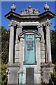
3
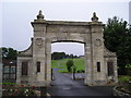
Kilbirnie War Memorial
Unveiled on 8th October 1922, as well as being a memorial to those that sacrificed their lives, it serves as a gateway to what was then a new public park. Lest we forget.
Image: © Chris Court
Taken: 10 Aug 2005
0.19 miles

5
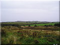
Distant Bunker
Rough Land adjacent to a Kilbirnie Housing estate, looking west to grazing land on Boagside Farm and a bunker on Kilbirnie Golf Course.
Image: © Chris Court
Taken: 11 Oct 2005
0.22 miles
6
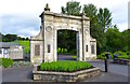
Kilbirnie War Memorial, North Ayrshire
Designed by James Houston of Kilbirnie, the War Memorial was unveiled in October 1922. The memorial also serves as the gateway to the Public Park.
Image: © Mark S
Taken: 23 Jul 2019
0.22 miles
7
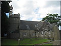
Kilbirnie Auld Kirk
The oldest parts date to the early fifteenth century but the building has been added to and altered many times since.
Image: © Jonathan Thacker
Taken: 20 Jul 2013
0.23 miles
8

Holmhead, Kilbirnie, North Ayrshire
Holmhead on a warm summer’s morning.
The ruined building on the right is part of the original Newhouse Farm.
Image: © Mark S
Taken: 23 Jul 2019
0.23 miles
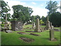
10
Memorial to Knox of Moorpark, Kilbirnie Cemetery
The Knox family owned the town's threadmills
Image: © Leslie Barrie
Taken: 16 May 2014
0.25 miles