IMAGES TAKEN NEAR TO
Causeyfoot Drive, KILBIRNIE, KA25 6AX
Introduction
This page details the photographs taken nearby to Causeyfoot Drive, KA25 6AX by members of the Geograph project.
The Geograph project started in 2005 with the aim of publishing, organising and preserving representative images for every square kilometre of Great Britain, Ireland and the Isle of Man.

There are currently over 7.5m images from over14,400 individuals and you can help contribute to the project by visiting https://www.geograph.org.uk
Image Map
Images are licensed for reuse under creativecommons.org/licenses/by-sa/2.0
Notes
- Clicking on the map will re-center to the selected point.
- The higher the marker number, the further away the image location is from the centre of the postcode.
Image Listing (47 Images Found)
Images are licensed for reuse under creativecommons.org/licenses/by-sa/2.0
Image
Details
Distance
1
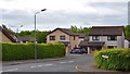
Castle Grove, Kilbirnie, North Ayrshire
Situated just off the A760 Largs Road, Castle Grove was built in the early 1990s and takes its name from the ruined Kilbirnie Castle nearby.
Image: © Mark S
Taken: 9 Jun 2020
0.15 miles
2
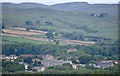
Kilbirnie from Glengarnock
The prominent building closest to the camera is located on Avils Hill, with the Fudstone scheme behind.
In the middle of the picture, nestled in the trees is Moorpark House.
To the top right of the photo is a former water treatment plant which after being derelict for many years has been converted into a private residence.
Image: © Mark S
Taken: 22 Jun 2019
0.16 miles
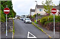
3
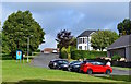
Ladysmith Road, Kilbirnie, North Ayrshire
Leading to the Fudstone Scheme.
Image: © Mark S
Taken: 23 Jul 2019
0.16 miles
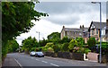
4
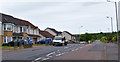
Largs Road, Kilbirnie, North Ayrshire
Looking along the A760 Largs Road.
The houses on the left were built around 2009.
Image: © Mark S
Taken: 9 Jun 2020
0.17 miles
5
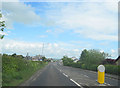
Entering Kilbirnie on the Largs road
From the west on the A760
Image: © John Firth
Taken: 11 May 2011
0.17 miles
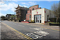
6
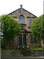
Masonic temple
Home of Lodge Royal Blues No. 399.
Image: © Mark Nightingale
Taken: 16 Jun 2011
0.17 miles
7
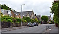
Avils Hill, Kilbirnie, North Ayrshire
Looking up Avils Hill from Newton Street.
Image: © Mark S
Taken: 20 Jun 2020
0.17 miles
8
Newton Street, Kilbirnie, North Ayrshire
Looking back along Newton Street towards St. Brigid’s Church.
Image: © Mark S
Taken: 4 Jul 2020
0.17 miles
9
Salvation Army, Kilbirnie
On Newton Street, south of Main Street.
Web site: https://www.salvationarmy.org.uk/kilbirnie .
Image: © Thomas Nugent
Taken: 13 Apr 2020
0.18 miles
10
Newton Street, Kilbirnie, North Ayrshire
From Newton Street we are looking towards Avils Place and on the right, tenements on Avils Hill.
Image: © Mark S
Taken: 4 Jul 2020
0.18 miles