IMAGES TAKEN NEAR TO
Kingsway, DALRY, KA24 5HE
Introduction
This page details the photographs taken nearby to Kingsway, KA24 5HE by members of the Geograph project.
The Geograph project started in 2005 with the aim of publishing, organising and preserving representative images for every square kilometre of Great Britain, Ireland and the Isle of Man.

There are currently over 7.5m images from over14,400 individuals and you can help contribute to the project by visiting https://www.geograph.org.uk
Image Map
Images are licensed for reuse under creativecommons.org/licenses/by-sa/2.0
Notes
- Clicking on the map will re-center to the selected point.
- The higher the marker number, the further away the image location is from the centre of the postcode.
Image Listing (9 Images Found)
Images are licensed for reuse under creativecommons.org/licenses/by-sa/2.0
Image
Details
Distance
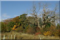
1
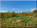
Plantation
A well established Larch plantation.
Image: © wfmillar
Taken: 27 Oct 2008
0.11 miles
3
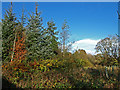
Mixed Woodland
Some new planting on the right.
Image: © wfmillar
Taken: 27 Oct 2008
0.16 miles
4
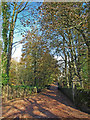
Drive at Broadlie House
This drive is walled either side and crosses Baidland Burn about 20 Mtrs.from the photographers spot.
Image: © wfmillar
Taken: 27 Oct 2008
0.19 miles
5
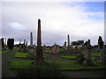
Headstones
19th Century headstones at Dalry Cemetery.
Image: © Chris Court
Taken: 29 Sep 2005
0.21 miles