IMAGES TAKEN NEAR TO
DALRY, KA24 4HQ
Introduction
This page details the photographs taken nearby to KA24 4HQ by members of the Geograph project.
The Geograph project started in 2005 with the aim of publishing, organising and preserving representative images for every square kilometre of Great Britain, Ireland and the Isle of Man.

There are currently over 7.5m images from over14,400 individuals and you can help contribute to the project by visiting https://www.geograph.org.uk
Image Map
Images are licensed for reuse under creativecommons.org/licenses/by-sa/2.0
Notes
- Clicking on the map will re-center to the selected point.
- The higher the marker number, the further away the image location is from the centre of the postcode.
Image Listing (8 Images Found)
Images are licensed for reuse under creativecommons.org/licenses/by-sa/2.0
Image
Details
Distance
1
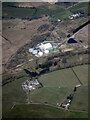
West Middlebank from the air
With Barkip biogas power station in the background and West Giffen Cottage in the right foreground.
Image: © Thomas Nugent
Taken: 21 Apr 2022
0.02 miles
4
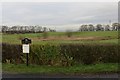
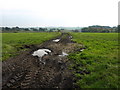
Wet depression
A waterlogged hollow at East Middlebank.
Image: © Richard Webb
Taken: 15 Nov 2014
0.10 miles
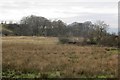
6
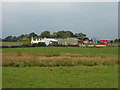
Middlebank pasture
Better looking grass than some fields around DM Beith. There is roll of old fencing wire in the foreground.
Image: © Richard Webb
Taken: 15 Nov 2014
0.12 miles
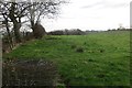
8
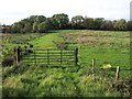
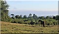
Gate and Field
Very rough grazing in this area.
Image: © wfmillar
Taken: 25 Sep 2008
0.22 miles