IMAGES TAKEN NEAR TO
DALRY, KA24 4HD
Introduction
This page details the photographs taken nearby to KA24 4HD by members of the Geograph project.
The Geograph project started in 2005 with the aim of publishing, organising and preserving representative images for every square kilometre of Great Britain, Ireland and the Isle of Man.

There are currently over 7.5m images from over14,400 individuals and you can help contribute to the project by visiting https://www.geograph.org.uk
Image Map
Images are licensed for reuse under creativecommons.org/licenses/by-sa/2.0
Notes
- Clicking on the map will re-center to the selected point.
- The higher the marker number, the further away the image location is from the centre of the postcode.
Image Listing (5 Images Found)
Images are licensed for reuse under creativecommons.org/licenses/by-sa/2.0
Image
Details
Distance
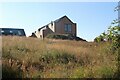
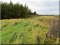
2
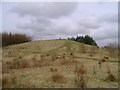
Pondery Hill
Pondery Hill is topped by the trig point visible here. Despite being barely noticeable from the lane passing to its west, its summit is higher than any point for a few miles in every direction.
Image: © Mark Nightingale
Taken: 23 Mar 2010
0.14 miles
3
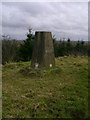
Triangulation pillar on Pondery Hill
The Ordnance Survey's iconic lump of concrete atop Pondery Hill.
Image: © Mark Nightingale
Taken: 23 Mar 2010
0.14 miles
4
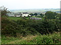
View from Pondery Hill Triangulation Pillar
Looking northward.
Image: © Peter Wood
Taken: 13 Sep 2016
0.17 miles