IMAGES TAKEN NEAR TO
DALRY, KA24 4EX
Introduction
This page details the photographs taken nearby to KA24 4EX by members of the Geograph project.
The Geograph project started in 2005 with the aim of publishing, organising and preserving representative images for every square kilometre of Great Britain, Ireland and the Isle of Man.

There are currently over 7.5m images from over14,400 individuals and you can help contribute to the project by visiting https://www.geograph.org.uk
Image Map
Images are licensed for reuse under creativecommons.org/licenses/by-sa/2.0
Notes
- Clicking on the map will re-center to the selected point.
- The higher the marker number, the further away the image location is from the centre of the postcode.
Image Listing (7 Images Found)
Images are licensed for reuse under creativecommons.org/licenses/by-sa/2.0
Image
Details
Distance
2
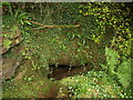
Cave, Cleeves Coves
One of the cave entrances. I did not venture in.
Image: © wfmillar
Taken: 26 Sep 2008
0.06 miles
3
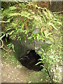
Cave, Cleeves Coves
Entrance to one of the caves.
Image: © wfmillar
Taken: 26 Sep 2008
0.07 miles
4
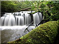
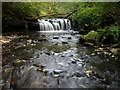
Cleeves Cove, Waterfall
A very damp and mossy location. The Dusk water makes its way down through Cleeves Glen past the Coves.
Image: © wfmillar
Taken: 26 Sep 2008
0.07 miles
6
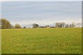
North Lissens
As usual in Ayrshire, grass.
Image: © Richard Webb
Taken: 15 Nov 2014
0.21 miles
7
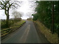
Lane northwest of Blair Mill
Looking east along a quiet lane a little west of the junction north of Blair Mill.
Image: © Mark Nightingale
Taken: 23 Mar 2010
0.23 miles