IMAGES TAKEN NEAR TO
WEST KILBRIDE, KA23 9RA
Introduction
This page details the photographs taken nearby to KA23 9RA by members of the Geograph project.
The Geograph project started in 2005 with the aim of publishing, organising and preserving representative images for every square kilometre of Great Britain, Ireland and the Isle of Man.

There are currently over 7.5m images from over14,400 individuals and you can help contribute to the project by visiting https://www.geograph.org.uk
Image Map (Loading...)


Getting Data...Please wait
Leaflet Map data © OpenStreetMap
Images are licensed for reuse under creativecommons.org/licenses/by-sa/2.0
Notes
- Clicking on the map will re-center to the selected point.
- The higher the marker number, the further away the image location is from the centre of the postcode.
Image Listing (14 Images Found)
Images are licensed for reuse under creativecommons.org/licenses/by-sa/2.0
Image
Details
Distance
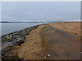
1
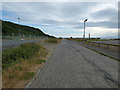
Power Station Road
Heading south from the power stations towards Portencross.
Image: © Thomas Nugent
Taken: 14 Jul 2018
0.09 miles
2
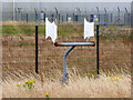
Airborne particle collector at Hunterston A power station
The device collects particles from the air for testing purposes.
See also Image
Image: © Thomas Nugent
Taken: 14 Jul 2018
0.09 miles
3
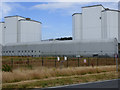
Hunterston A nuclear power station
The device in the foreground collects particles from the air for testing purposes. The building in the foreground is used for storing low level irradiated materials during the power station decommissioning process
See also Image
Image: © Thomas Nugent
Taken: 14 Jul 2018
0.10 miles
4
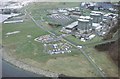
Hunterston Nuclear Power Station
This view of Hunterston Power Station was taken from a model aircraft. The 'A' Station (now decommissioned) is in the centre right and the 'B' station is in the top right.
Image: © Kenneth Hall
Taken: Unknown
0.12 miles
5
Track at Hunterston Nuclear Power Station
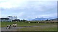
The Wee cumbrae in the distance left, Big Cumbrae to the right. Note for non-locals - although the OS names the two islands 'Little Cumbrae Island' and 'Great Cumbrae Island' they are ALWAYS known to locals as 'Wee Cumbrae' and 'Big Cumbrae'.
Image: © Gordon Brown
Taken: 5 Feb 2015
0.13 miles
6
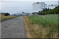
Hunterston A
Looking north on Power Station Road.
Image: © Thomas Nugent
Taken: 14 Jul 2018
0.14 miles
7
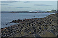
Little Brigurd, Hunterston
These sea defences are in the process of being fortified, you can see the handling marks on the rocks. Looking towards Millport.
Image: © wfmillar
Taken: 6 Feb 2008
0.14 miles
8
Hunterston 'A' Power Station
Hunterston 'A' Power Station from the Ayrshire Coastal Path.
Image: © Raibeart MacAoidh
Taken: 26 Sep 2017
0.14 miles
9
Hunterston Power Station
Looking towards Huterston A nuclear power station
Image: © Raibeart MacAoidh
Taken: 24 Apr 2016
0.18 miles
10
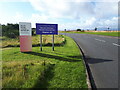
Confusion - then clarity of signs?
The explanation is that at this point we leave the licensed site for Hunterston 'B' AGR reactor, still operating, and enter the site of Hunterston 'A' Magnox reactor, currently being decommissioned.
Image: © Gordon Brown
Taken: 29 Sep 2020
0.19 miles