IMAGES TAKEN NEAR TO
ARDROSSAN, KA22 8PJ
Introduction
This page details the photographs taken nearby to KA22 8PJ by members of the Geograph project.
The Geograph project started in 2005 with the aim of publishing, organising and preserving representative images for every square kilometre of Great Britain, Ireland and the Isle of Man.

There are currently over 7.5m images from over14,400 individuals and you can help contribute to the project by visiting https://www.geograph.org.uk
Image Map
Images are licensed for reuse under creativecommons.org/licenses/by-sa/2.0
Notes
- Clicking on the map will re-center to the selected point.
- The higher the marker number, the further away the image location is from the centre of the postcode.
Image Listing (10 Images Found)
Images are licensed for reuse under creativecommons.org/licenses/by-sa/2.0
Image
Details
Distance
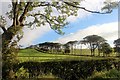
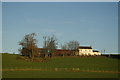
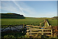
1

Meadowhead Cottage
Just at the head of the track from the Ayrshire coast.
Image: © Gordon Brown
Taken: 18 Jan 2022
0.02 miles
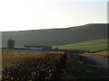
6
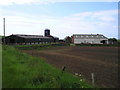
Meadowhead Farm
The Ordnance Survey map shows this grid as having a minor road which passes through this farm and then joining the A78 coast road, but unless you have a 4x4 off road vehicle I wouldn't advise this route as it is very overgrown with a poor road surface ( ie no road surface )
Image: © Ian Rainey
Taken: 13 Jun 2006
0.16 miles
9
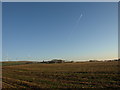
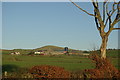
Stubble Field
Looking towards Hauplands Farm.
Image: © wfmillar
Taken: 12 Feb 2008
0.24 miles
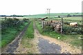
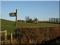
10
Ditch near Meadowhead
A view towards Tarbert Hill
Image: © Leslie Barrie
Taken: 6 Dec 2008
0.25 miles