IMAGES TAKEN NEAR TO
Knockrivoch Gardens, ARDROSSAN, KA22 7QB
Introduction
This page details the photographs taken nearby to Knockrivoch Gardens, KA22 7QB by members of the Geograph project.
The Geograph project started in 2005 with the aim of publishing, organising and preserving representative images for every square kilometre of Great Britain, Ireland and the Isle of Man.

There are currently over 7.5m images from over14,400 individuals and you can help contribute to the project by visiting https://www.geograph.org.uk
Image Map
Images are licensed for reuse under creativecommons.org/licenses/by-sa/2.0
Notes
- Clicking on the map will re-center to the selected point.
- The higher the marker number, the further away the image location is from the centre of the postcode.
Image Listing (4 Images Found)
Images are licensed for reuse under creativecommons.org/licenses/by-sa/2.0
Image
Details
Distance
1
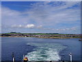
Ardrossan From Arran Ferry
View from the Arran Ferry, shortly after departure.
Image: © Eleanor Graham
Taken: 10 Jul 2005
0.16 miles
3
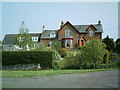
Whitlees Farm
Whitlees Farm used to be out in the open but now private housing has been built which encroaches almost into this picture. The private housing estate is only just off the right side of this photo.
Image: © Ian Rainey
Taken: 9 May 2006
0.20 miles
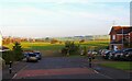
4
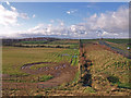
Field above Ardrossan/Saltcoats
The tractors have churned up this field after the harvest. Looks waterlogged now. The bypass on the right, Chapelhill on the left and Arran under cloud.
Image: © wfmillar
Taken: 26 Nov 2009
0.24 miles