IMAGES TAKEN NEAR TO
Munnoch Crescent, ARDROSSAN, KA22 7PW
Introduction
This page details the photographs taken nearby to Munnoch Crescent, KA22 7PW by members of the Geograph project.
The Geograph project started in 2005 with the aim of publishing, organising and preserving representative images for every square kilometre of Great Britain, Ireland and the Isle of Man.

There are currently over 7.5m images from over14,400 individuals and you can help contribute to the project by visiting https://www.geograph.org.uk
Image Map
Images are licensed for reuse under creativecommons.org/licenses/by-sa/2.0
Notes
- Clicking on the map will re-center to the selected point.
- The higher the marker number, the further away the image location is from the centre of the postcode.
Image Listing (11 Images Found)
Images are licensed for reuse under creativecommons.org/licenses/by-sa/2.0
Image
Details
Distance
1
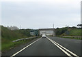
A78 approaching railway bridge at end of by pass
Image: © John Firth
Taken: 27 Jul 2012
0.16 miles

3
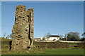
Montfode Castle & farm
Remains of a 16th-century Z-plan tower house of the Montfodes of that Ilk. The family became extinct in the 17th-century. In the 19th-century the castle was mostly demolished; the stonework being used in the construction of a nearby mill.
Image: © Leslie Barrie
Taken: 6 Dec 2008
0.18 miles
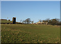
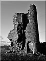
5
Montfode Castle
The name 'Montfode' derives from the old Norman family of that name, the Montfodes of that Ilk. The castle was mostly demolished in the early 19th century to provide stone to build a dam and threshing mill at Montfode Farm.
The remaining fragment of this baronial castle consists of a single round tower, with slits and a gun-loop, standing to around 8m with an interior diameter of 2m.
The doorway on the eastern side has moulded stone surround. The tower and wall are of rubble masonry and 0.7m thick. The position of this tower, situated upon an exterior angle, may indicate that the building was of a Z-plan construction.
Image: © Raibeart MacAoidh
Taken: 28 Dec 2017
0.20 miles
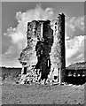
6
Montfode Castle
The name 'Montfode' derives from the old Norman family of that name, the Montfodes of that Ilk. The castle was mostly demolished in the early 19th century to provide stone to build a dam and threshing mill at Montfode Farm.
The remaining fragment of this baronial castle consists of a single round tower, with slits and a gun-loop, standing to around 8m with an interior diameter of 2m.
The doorway on the eastern side has moulded stone surround. The tower and wall are of rubble masonry and 0.7m thick. The position of this tower, situated upon an exterior angle, may indicate that the building was of a Z-plan construction.
Image: © Raibeart MacAoidh
Taken: 28 Dec 2017
0.20 miles
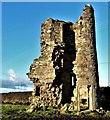
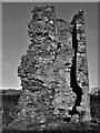
7
Montfode Castle
The name 'Montfode' derives from the old Norman family of that name, the Montfodes of that Ilk. The castle was mostly demolished in the early 19th century to provide stone to build a dam and threshing mill at Montfode Farm.
The remaining fragment of this baronial castle consists of a single round tower, with slits and a gun-loop, standing to around 8m with an interior diameter of 2m.
The doorway on the eastern side has moulded stone surround. The tower and wall are of rubble masonry and 0.7m thick. The position of this tower, situated upon an exterior angle, may indicate that the building was of a Z-plan construction.
Image: © Raibeart MacAoidh
Taken: 8 Nov 2018
0.20 miles
8

Montfode Castle
The name 'Montfode' derives from the old Norman family of that name, the Montfodes of that Ilk. The castle was mostly demolished in the early 19th century to provide stone to build a dam and threshing mill at Montfode Farm.
The remaining fragment of this baronial castle consists of a single round tower, with slits and a gun-loop, standing to around 8m with an interior diameter of 2m.
The doorway on the eastern side has moulded stone surround. The tower and wall are of rubble masonry and 0.7m thick. The position of this tower, situated upon an exterior angle, may indicate that the building was of a Z-plan construction.
Image: © Raibeart MacAoidh
Taken: 8 Nov 2018
0.20 miles
9
Montfode Castle
The name 'Montfode' derives from the old Norman family of that name, the Montfodes of that Ilk. The castle was mostly demolished in the early 19th century to provide stone to build a dam and threshing mill at Montfode Farm.
The remaining fragment of this baronial castle consists of a single round tower, with slits and a gun-loop, standing to around 8m with an interior diameter of 2m.
The doorway on the eastern side has moulded stone surround. The tower and wall are of rubble masonry and 0.7m thick. The position of this tower, situated upon an exterior angle, may indicate that the building was of a Z-plan construction.
Image: © Raibeart MacAoidh
Taken: 28 Dec 2017
0.20 miles
10

All that remains of Montfode Castle
See also https://www.geograph.org.uk/photo/5969420
Image: © Gordon Brown
Taken: 18 Jan 2022
0.20 miles