IMAGES TAKEN NEAR TO
MAYBOLE, KA19 8LU
Introduction
This page details the photographs taken nearby to KA19 8LU by members of the Geograph project.
The Geograph project started in 2005 with the aim of publishing, organising and preserving representative images for every square kilometre of Great Britain, Ireland and the Isle of Man.

There are currently over 7.5m images from over14,400 individuals and you can help contribute to the project by visiting https://www.geograph.org.uk
Image Map
Images are licensed for reuse under creativecommons.org/licenses/by-sa/2.0
Notes
- Clicking on the map will re-center to the selected point.
- The higher the marker number, the further away the image location is from the centre of the postcode.
Image Listing (14 Images Found)
Images are licensed for reuse under creativecommons.org/licenses/by-sa/2.0
Image
Details
Distance
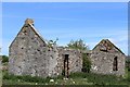
1
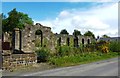
The Old Dalquharran School
Dalquharran School was built at Wallacetown around 1906 by the coal-owners who were aware of their responsibilities to the workforce. In 1896, Dalquharran Estate employed over 110 people at the pit, most of them working underground and some on the surface. The school closed in 1926.
Image: © Mary and Angus Hogg
Taken: 22 May 2016
0.03 miles
3
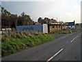
Burninghill Wood Colliery Site
The name Burninghill Wood comes from an incident in 1749 when a pit here collapsed and caught fire. The heat began to burn the surrounding coal leading to an underground fire that lasted into the 1880s. Steam and smoke were often seen at surface. Another part of the valley side, 2-3 miles away, is also called Burning Hill and marks the other end of the same incident. There’s still a smell of tar in Glenshalloch Wood in Image
Image: © Mary and Angus Hogg
Taken: 22 May 2016
0.08 miles
4
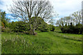
In Burninghill Wood
This is not really a wood, just some scrubby trees and bushes on an old colliery site. The name gives a clue to its history. The workings at this site collapsed in 1749, leading to a serious underground fire. Ignition came from an underground furnace, which was there to create a draught for pit ventilation. The collapsed timbers caught fire first at a depth of 200 feet, followed by the pit head frame on the surface. The coal dust ignited, then the coal near the surface and finally the reserves below ground level. The fire spread along the hill underground and lasted into the 1880s in spite of attempts to close it down and flood it. Steam and gases filtered up to the surface until the early 20th century. There’s still a smell of tar in Glenshalloch Wood in Image
Image: © Mary and Angus Hogg
Taken: 22 May 2016
0.09 miles
5
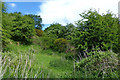
Old Colliery Workings at Burninghill
The name Burning Hill Wood comes from an incident here in 1749 when the pit collapsed and caught fire. The heat began to burn the surrounding coal leading to an underground fire that spread as far as Tradunnock Hill in NS 2904 and lasted into the 1880s. Occasional bursts of steam and smoke were still being seen at surface in the early 20th century.
Image: © Mary and Angus Hogg
Taken: 22 May 2016
0.12 miles
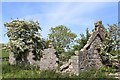
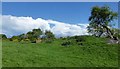
6
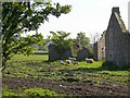
Sheep at the ruined building
The OS maps of the 1850s show a tileworks on this site. Drainage tiles were in big demand for the agricultural improvements that started here in the 18th century.
Image: © Mary and Angus Hogg
Taken: 9 Jun 2007
0.14 miles