IMAGES TAKEN NEAR TO
MAYBOLE, KA19 8LN
Introduction
This page details the photographs taken nearby to KA19 8LN by members of the Geograph project.
The Geograph project started in 2005 with the aim of publishing, organising and preserving representative images for every square kilometre of Great Britain, Ireland and the Isle of Man.

There are currently over 7.5m images from over14,400 individuals and you can help contribute to the project by visiting https://www.geograph.org.uk
Image Map
Images are licensed for reuse under creativecommons.org/licenses/by-sa/2.0
Notes
- Clicking on the map will re-center to the selected point.
- The higher the marker number, the further away the image location is from the centre of the postcode.
Image Listing (10 Images Found)
Images are licensed for reuse under creativecommons.org/licenses/by-sa/2.0
Image
Details
Distance
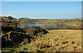
1
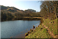
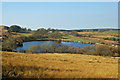
Lochspouts Shore
The far end of Lochspouts, near the farm. Lochspouts was the reservoir for Maybole and nearby villages until the new supply at Loch Bradan was introduced in the late 1970s. The loch was managed by the Maybole Angling Club until the cost of maintenance proved prohibitive. It's a glacial kettle lake.
Image: © Mary and Angus Hogg
Taken: 12 Mar 2014
0.07 miles
2
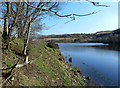
The Edge Of Lochspouts
Lochspouts was the reservoir for Maybole and nearby villages until the new supply at Loch Bradan was introduced in the late 1970s. The loch was managed by the Maybole Angling Club until the cost of maintenance proved prohibitive. It's a glacial kettle lake.
Image: © Mary and Angus Hogg
Taken: 12 Mar 2014
0.14 miles
3
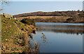
Lochspouts
Lochspouts was the reservoir for Maybole and nearby villages until the new supply at Loch Bradan was introduced in the late 1970s. The loch was managed by the Maybole Angling Club until the cost of maintenance proved prohibitive. It's a glacial kettle lake. This view looks towards Craigfin Hill.
Image: © Mary and Angus Hogg
Taken: 12 Mar 2014
0.16 miles
4
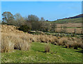
Burncrooks Burn
Burncrooks Burn, viewed at the end of Ghaist Glen, near Lochspouts.
Image: © Mary and Angus Hogg
Taken: 12 Mar 2014
0.18 miles
5
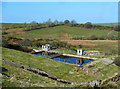
Lochspouts Waterworks
Lochspouts was the reservoir for Maybole and nearby villages until the new supply at Loch Bradan was introduced in the late 1970s. The old waterworks are still there. Lochspouts water was dark in colour and tasted fantastically good.
Image: © Mary and Angus Hogg
Taken: 12 Mar 2014
0.19 miles
6
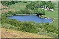
Lochspouts Reservoir
A small reservoir viewed from Craigfin Hill with Lochspouts Farm behind.
Image: © Walter Baxter
Taken: 16 May 2008
0.20 miles
7
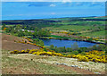
Lochspouts
Viewed from the next square on a lovely early-May morning.
Image: © Mary and Angus Hogg
Taken: 4 May 2020
0.20 miles
8
Approaching Lochspouts
Lochspouts was the reservoir for Maybole and nearby villages until the new supply at Loch Bradan was introduced in the late 1970s. The loch was managed by the Maybole Angling Club until the cost of maintenance proved prohibitive. It's a glacial kettle lake.
Image: © Mary and Angus Hogg
Taken: 12 Mar 2014
0.22 miles
9
Lochspouts
Lochspouts was the reservoir for Maybole and nearby villages until the new supply at Loch Bradan was introduced in the late 1970s. The loch was managed by the Maybole Angling Club until the cost of maintenance proved prohibitive. It's a glacial kettle lake.
Image: © Mary and Angus Hogg
Taken: 12 Mar 2014
0.22 miles
10
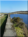
Lochspouts View
Looking along the old dam at Lochspouts, which was the reservoir for Maybole and nearby villages until the new supply at Loch Bradan was introduced in the late 1970s. The loch was managed by the Maybole Angling Club until the cost of maintenance proved prohibitive. It's a glacial kettle lake.
Image: © Mary and Angus Hogg
Taken: 12 Mar 2014
0.23 miles