IMAGES TAKEN NEAR TO
MAYBOLE, KA19 8EJ
Introduction
This page details the photographs taken nearby to KA19 8EJ by members of the Geograph project.
The Geograph project started in 2005 with the aim of publishing, organising and preserving representative images for every square kilometre of Great Britain, Ireland and the Isle of Man.

There are currently over 7.5m images from over14,400 individuals and you can help contribute to the project by visiting https://www.geograph.org.uk
Image Map
Images are licensed for reuse under creativecommons.org/licenses/by-sa/2.0
Notes
- Clicking on the map will re-center to the selected point.
- The higher the marker number, the further away the image location is from the centre of the postcode.
Image Listing (3 Images Found)
Images are licensed for reuse under creativecommons.org/licenses/by-sa/2.0
Image
Details
Distance
1
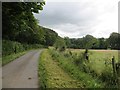
Carrick Hills road, Sauchrie
One verge had just been mown.
Image: © Richard Webb
Taken: 13 Aug 2014
0.09 miles
2
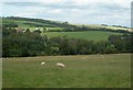
Towards Sauchrie
Rich farmland on the lower slopes of the north Carrick Hills at Sauchrie, viewed from NS3013.
Image: © Mary and Angus Hogg
Taken: 31 Aug 2006
0.14 miles
3
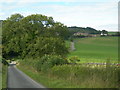
Sauchrie
Looking N across the burn towards Sauchrie Farm, from Cycle Route 7
Image: © Mary and Angus Hogg
Taken: 31 Aug 2006
0.19 miles