IMAGES TAKEN NEAR TO
Kirkoswald Road, MAYBOLE, KA19 8BP
Introduction
This page details the photographs taken nearby to Kirkoswald Road, KA19 8BP by members of the Geograph project.
The Geograph project started in 2005 with the aim of publishing, organising and preserving representative images for every square kilometre of Great Britain, Ireland and the Isle of Man.

There are currently over 7.5m images from over14,400 individuals and you can help contribute to the project by visiting https://www.geograph.org.uk
Image Map
Images are licensed for reuse under creativecommons.org/licenses/by-sa/2.0
Notes
- Clicking on the map will re-center to the selected point.
- The higher the marker number, the further away the image location is from the centre of the postcode.
Image Listing (101 Images Found)
Images are licensed for reuse under creativecommons.org/licenses/by-sa/2.0
Image
Details
Distance
1
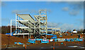
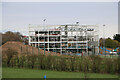
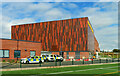
A new educational hub for Maybole
The new hub will be built on the site of the existing Carrick Academy and will provide the full range of secondary, primary and early years provision. Community services will include a new swimming pool and sports facilities. The target opening date is early 2023.
Image: © Mary and Angus Hogg
Taken: 19 Feb 2022
0.00 miles
2
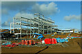
Maybole Community Campus site
The new Community Campus will be built on the site of the existing Carrick Academy and will provide the full range of secondary, primary and early years services as well as community facilities. The site plan shows that all existing buildings are to be demolished. Time will tell if the new school, scheduled to open in 2023, will last as long as the old one, which opened in 1926. Image
Image: © Mary and Angus Hogg
Taken: 19 Feb 2022
0.00 miles
3
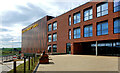
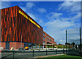
Maybole’s state of the art community campus
The new services represent a major investment in Maybole and should make a good contribution to plans for the town’s regeneration. This view shows the entrance to Carrick Academy.
Image: © Mary and Angus Hogg
Taken: 9 Sep 2023
0.02 miles
4
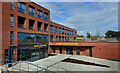
Primary and Early Years education at Maybole
This brand-new facility replaces the former Cairn and Gardenrose schools with a new combined service called Culzean Primary School. The building also accommodates St Cuthbert’s Primary School and new Early Years services. The old schools are shown at Image, Image and Image
Image: © Mary and Angus Hogg
Taken: 9 Sep 2023
0.02 miles
5
New Maybole Community Campus
Viewed from the A77. Targeted to open early 2023.
Image: © Billy McCrorie
Taken: 10 Apr 2022
0.05 miles
6
New educational facilities at Maybole
Looking along the front of the new building from the sports pavilion to the new Carrick Academy. The primary and early years services lie further on. The schools are already open although a lot of work is still to be done on the site. Image shows a similar view taken at an early stage of the development.
Image: © Mary and Angus Hogg
Taken: 9 Sep 2023
0.05 miles
7
Maybole Community Campus
This view shows the sports pavilion end of the new Community Campus. The development includes a new swimming pool which will be made available to the public outside school hours.
Image: © Mary and Angus Hogg
Taken: 9 Sep 2023
0.05 miles
8
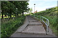
Steps leading to McAdam Way, Maybole
From Whitefaulds Avenue.
Image: © Billy McCrorie
Taken: 14 May 2022
0.06 miles
9
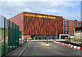
Maybole Police Office
The police service was relocated into Maybole Community Hub in 2023, using brand-new premises beside the new schools. The old service was located in Ladyland Road, next to the local Ambulance Service - see Image
Image shows a similar view taken at an early stage of the building project.
Image: © Mary and Angus Hogg
Taken: 9 Sep 2023
0.08 miles
10
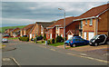
McAdam Way, Maybole
These new houses on the west side of Maybole enjoy spectacular views of the Carrick countryside and catch all the sun that's going.
Image: © Mary and Angus Hogg
Taken: 2 May 2014
0.08 miles