IMAGES TAKEN NEAR TO
Craigie Avenue, MAYBOLE, KA19 8BD
Introduction
This page details the photographs taken nearby to Craigie Avenue, KA19 8BD by members of the Geograph project.
The Geograph project started in 2005 with the aim of publishing, organising and preserving representative images for every square kilometre of Great Britain, Ireland and the Isle of Man.

There are currently over 7.5m images from over14,400 individuals and you can help contribute to the project by visiting https://www.geograph.org.uk
Image Map
Images are licensed for reuse under creativecommons.org/licenses/by-sa/2.0
Notes
- Clicking on the map will re-center to the selected point.
- The higher the marker number, the further away the image location is from the centre of the postcode.
Image Listing (316 Images Found)
Images are licensed for reuse under creativecommons.org/licenses/by-sa/2.0
Image
Details
Distance
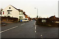
1
Cargill Avenue
One of the routes leading into modern housing areas in Maybole. The road is named after the Covenanting preacher, Donald Cargill, who was very active in this area during the mid-17th century.
Image: © Mary and Angus Hogg
Taken: 25 Feb 2018
0.03 miles
2
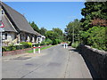
Cargill Road, Maybole
The road runs beside the railway (right).
Image: © Richard Webb
Taken: 13 Aug 2014
0.08 miles
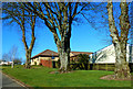
3
Elms Drive, Maybole
Part of a modern housing development on the north side of Maybole.
Image: © Mary and Angus Hogg
Taken: 25 Feb 2018
0.08 miles
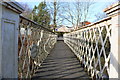
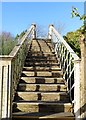
4
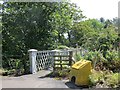
Footbridge, Cargill Road
A bridge across the railway north of the town centre.
Image: © Richard Webb
Taken: 13 Aug 2014
0.10 miles
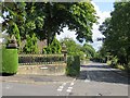
7
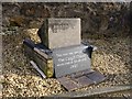
Cargill Stone, Cargill Court, Maybole
This stone was rescued from the Cargill Memorial Church in Maybole when it was demolished in 1985. The stone was originally located to the north of the town, where a monument commemorates all of the Covenanters of the district (see http://www.geograph.org.uk/photo/2278703 ) but it was broken and part of it was incorporated in the Cargill church. The stone lay in the yard of a local builder for a few years before it was rescued and incorporated into this small memorial, located at the entrance to Cargill Court, the new houses erected on the site of the church. The stone was unveiled at a conventicle on Sunday 5th November 2006.
The Cargill Stone was the location of a number of conventicles held by
Rev. Donald Cargill and others during the time of the struggles. Cargill’s last conventicle here took place in 1681, just two months before he was arrested at Covington in Lanarkshire and subsequently executed in Edinburgh.
(Information from the Scottish Covenanter Memorials Association)
Image: © Becky Williamson
Taken: 15 Feb 2011
0.11 miles
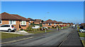
8
Cargill Road
Cargill rd next to the junction with Gardenrose Path.
Image: © Billy McCrorie
Taken: 13 Jul 2011
0.11 miles
9
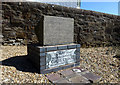
The Cargill Stone
Located at the entrance to Cargill Court, a housing development on the site of the former Cargill Church. The inscription explains:
This is part of a stone beside which Donald Cargill is believed to have conducted a Conventicle on the farm of Cargillstone during the Covenanting period 1638-1688.
The above stone was once part of the Cargill Church which stood here 1844-1985. The approximate site of the Conventicle is shown at Image and the Covenanters' Monument with more information is shown at Image
Image: © Mary and Angus Hogg
Taken: 20 Apr 2016
0.12 miles