IMAGES TAKEN NEAR TO
MAYBOLE, KA19 7SB
Introduction
This page details the photographs taken nearby to KA19 7SB by members of the Geograph project.
The Geograph project started in 2005 with the aim of publishing, organising and preserving representative images for every square kilometre of Great Britain, Ireland and the Isle of Man.

There are currently over 7.5m images from over14,400 individuals and you can help contribute to the project by visiting https://www.geograph.org.uk
Image Map
Images are licensed for reuse under creativecommons.org/licenses/by-sa/2.0
Notes
- Clicking on the map will re-center to the selected point.
- The higher the marker number, the further away the image location is from the centre of the postcode.
Image Listing (9 Images Found)
Images are licensed for reuse under creativecommons.org/licenses/by-sa/2.0
Image
Details
Distance
1
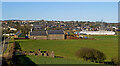
Maybole from Auchenwynd, 2021
This 2021 wide-angle view of Maybole, taken from Auchenwynd Farm, shows the extent of housing on the hillside near Gardenrose Primary School. The factory building on the left is the home of SAS International, a company that supplies the building trade with metal-worked products such as doors and suspended ceilings. The factory was built on the site of the former Ladywell Factory where hard-wearing boots were produced. The trade collapsed in the early 20th century, having made a world-famous Maybole product for many years. For a similar earlier view, see Image
Image: © Mary and Angus Hogg
Taken: 22 Feb 2021
0.03 miles
2
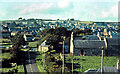
Maybole from Auchenwynd, 1974
This 1974 view of Maybole, taken from Auchenwynd Farm, shows the then-new council housing development around Minnoch Crescent near the top of the hill on the left. With typical west of Scotland humour, the development quickly became known as “high living”. Gardenrose Primary School, opened in 1972, is shown on the crest of the hill beside farmland that is now a residential site. For an up to date view, see Image
Image: © Mary and Angus Hogg
Taken: Unknown
0.13 miles
3
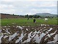
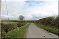
Cattle, Back Hill of Kilhenzie
Evidence of recent heavy rain. I was glad to be on the road today.
Image: © Richard Webb
Taken: 13 Aug 2014
0.17 miles
4
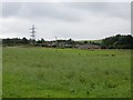
Substation, Maybole
The railway is up there too.
Image: © Richard Webb
Taken: 13 Aug 2014
0.23 miles
5
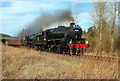
Steaming on to Girvan
A memorable sight on the Glasgow-Stranraer line on 10 April - the Great Britain III tour, an 11-coach train hauled by Stanier Black 5 locomotives 44871 and 45407. Viewed just after leaving Maybole on the outward run.
Image: © Mary and Angus Hogg
Taken: 10 Apr 2010
0.24 miles
6
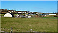
Auchenwynd Holdings view
A mid-February view looking towards Auchenwynd Holdings with Maybole in the background. The buildings, formerly a small farm, were called Balloney in years gone by. The factory building on the left, in the next square, is the home of SAS International, a company that supplies the building trade with metal-worked products such as doors and suspended ceilings.
Image: © Mary and Angus Hogg
Taken: 22 Feb 2021
0.24 miles
8
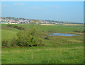
Auchenwynd Marsh
Wetland area on Auchenwynd Farm, with Maybole in the background
Image: © Mary and Angus Hogg
Taken: 15 Oct 2006
0.24 miles
9
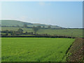
New Grass
A field of new grass on Auchenwynd Farm, with Knockbrake Hill in the background
Image: © Mary and Angus Hogg
Taken: 15 Oct 2006
0.24 miles