IMAGES TAKEN NEAR TO
Straiton, MAYBOLE, KA19 7QS
Introduction
This page details the photographs taken nearby to KA19 7QS by members of the Geograph project.
The Geograph project started in 2005 with the aim of publishing, organising and preserving representative images for every square kilometre of Great Britain, Ireland and the Isle of Man.

There are currently over 7.5m images from over14,400 individuals and you can help contribute to the project by visiting https://www.geograph.org.uk
Image Map
Images are licensed for reuse under creativecommons.org/licenses/by-sa/2.0
Notes
- Clicking on the map will re-center to the selected point.
- The higher the marker number, the further away the image location is from the centre of the postcode.
Image Listing (5 Images Found)
Images are licensed for reuse under creativecommons.org/licenses/by-sa/2.0
Image
Details
Distance
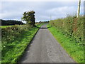
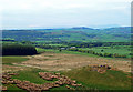
2
Towards Knockgardner Farm
Viewed from the Black Hill of Knockgardner in the next square.
Image: © Mary and Angus Hogg
Taken: 20 May 2020
0.01 miles
3
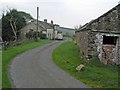
Knockgardner
An isolated farm near Straiton.
Image: © Oliver Dixon
Taken: 17 Oct 2006
0.01 miles
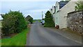
4
Road approaching Knockgardner
Looking south-westward.
Image: © Peter Wood
Taken: 15 Sep 2017
0.12 miles
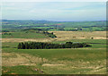
5
View to Kirkbride Farm
Viewed from outside the square on the top of the Black Hill of Knockgdardner during a Coronavirus exercise outing. Mochrum Hill is visible in the distance with a hazy island of Arran in the background.
Image: © Mary and Angus Hogg
Taken: 20 May 2020
0.22 miles